No CrossRef data available.
Article contents
Abstract

- Type
- Liber Eliensis
- Information
- Copyright
- Copyright © Royal Historical Society 1962
References
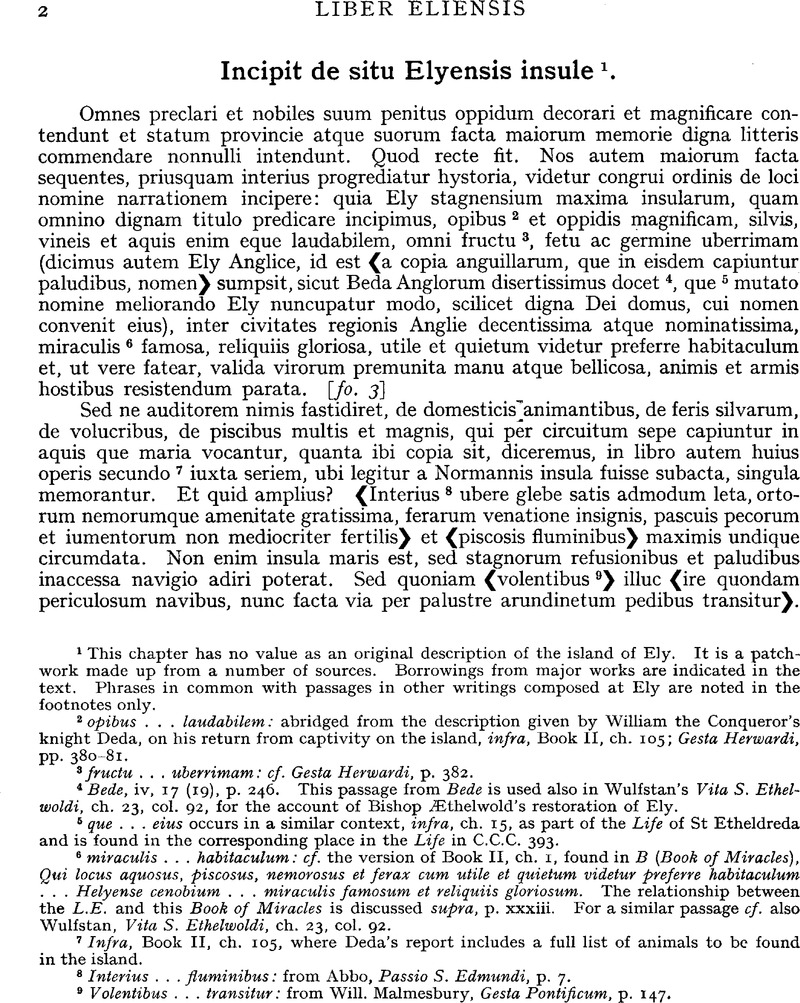
page 2 note 2 opibus … laudabilem: abridged from the description given by William the Conqueror's knight Deda, on his return from captivity on the island, infra, Book II, ch. 105; Gesta Herwardi, pp. 380–81.
page 2 note 3 fructu … uberrimam: cf. Gesta Herwardi, p. 382.
page 2 note 4 Bede, iv, 17 (19), p. 246. This passage from Bede is used also in Wulfstan's Vita S. Ethelwoldi, ch. 23, col. 92, for the account of Bishop Æthelwold's restoration of Ely.
page 2 note 5 que … eius occurs in a similar context, infra, ch. 15, as part of the Life of St Etheldreda and is found in the corresponding place in the Life in C.C.C. 393.
page 2 note 6 miraculis … habitaculum: cf. the version of Book II, ch. 1, found in B (Book of Miracles), Qui locus aquosus, piscosus, nemorosus et ferax cum utile et quietum videtur preferre habitaculum … Helyense cenobium … miraculis famosum et reliquiis gloriosum. The relationship between the L.E. and this Book of Miracles is discussed supra, p. xxxiii. For a similar passage cf. also Wulfstan, Vita S. Ethelwoldi, ch. 23, col. 92.
page 2 note 7 Infra, Book II, ch. 105, where Deda's report includes a full list of animals to be found in the island.
page 2 note 8 Interius … fluminibus: from Abbo, Passio S. Edmundi, p. 7.
page 2 note 9 Volentibus … transitur: from Will. Malmesbury, Gesta Pontificum, p. 147.
page 3 note 1 These are the limits of the island, as distinct from the administrative Isle, of Ely, which are said to have been determined by the authority of King Edgar by Abbot Brihtnoth's prepositus Leo, who perpetuated the settlement of one particular boundary dispute by cutting the Abbotsdelf. This chapter should be read with infra, Book II, ch. 54, where these details are given. The exact location of these boundaries, except for Littleport and Stretham Mere, are still the subject of discussion (cf. Miller, Ely, pp. 12–13). It has been suggested that Cotingelade was the name of a little tributary which came to form a stretch of the Old West river (Fowler, G., P.C.A.S., xxxiii, 124Google Scholar, with map), but it has also been identified with part of the Bean Ditch which once separated Stretham and Cottenham fens (Miller, Ely, p. 12, n. 5, citing Wells, S., Laws of the Bedford Level Corporation, ii, 175, 177)Google Scholar. Either identification would be compatible with another reference to Cotingelade in connection with William I's attack on the island in 1071 (infra, Book II, ch. 107), but this depends on the further identification of Alreheðe with Aldreth. The Abbotsdelf has usually been identified with the Crooked Drain, since the name seems to have been preserved in Delph Bridge. But Fowler's view that it continued the Crooked Drain in a North Easterly direction towards Shippea Hill station, if accepted, would make it a more obvious alternative to Littleport as the terminal point of a measurement of the length of the island. See Miller, Ely, p. 12, n. 5 (ii), citing Fowler, , P.C.A.S., xxxiv, 17, 27, with mapGoogle Scholar.
page 3 note 2 This sentence, like the next, does not belong to the tenth-century description (supra, n. 1), but refers to conditions in the twelfth century, when the term insula had come to embrace possessions of the abbey outside the island. Cf. Miller, Ely, p. 14 and sketch-map facing p. 220, and in V.C.H., Cambs., iv, 1–8. Cf. also infra, Book II, ch. 54.
page 3 note 3 This is the later Ely hundred with the addition of what was to become the hundred of Wisbech (see infra, Book II, ch. 75), as the bounds from Upware to Tyd and Bishopsdelf to the neighbourhood of Peterborough show. According to Miller this division into two hundreds was no more than a fiscal arrangement to produce two hundreds of roughly 40 hides each, while they formed a single unit of administration (Miller, Ely, p. 31).
page 3 note 4 This passage has been the subject of frequent comment. Bede's, Elge in provincia Orientalium Anglorum regio familiarum circiter sexcentarum (iv, 17 (19), p. 246)Google Scholar has been tentatively identified with the province of the Southern Gyrwe, rated at 600 hides in the Tribal Hidage. On these and the further grounds that the element ge may represent the equivalent of the Germanic gau and that Tondbert is called princeps Australium Gyrviorum (Bede, iv, 17 (19), p. 243) Ely is thought to have been the centre of a provincia or regio, having its origin in the first stages of the Anglo-Saxon settlement, which according to the Ely tradition would then have been given by Tondbert to Etheldreda iure dotis (infra) and which was eventually restored to Bishop Æthelwold's foundation in the shape of the two hundreds of the Isle. The difficulties of this interpretation are most fully discussed by Miller (Ely, p. ii ), who suggests plausibly that only the island itself passed into Etheldreda's hands (ibid., pp. 9–14). Cf. H. M. Chadwick, The Origin of the English Nation (1924), pp. 8–9 and H. C. Darby in Antiquity, viii, 194–201.
page 4 note 1 In 1771 the name still survived as Cratendon Field ‘ about a mile South of the present city ’ according to Bentham, Ely, i, 54.
page 4 note 2 Supra, p. 3, n. 4. This must be a local tradition which found its way into Edward the Confessor's charter of confirmation (infra, Book II, ch. 92), but for which there is no corroboration from an independent source.
page 4 note 3 This information probably comes from a local set of annals. It is included among the chronological entries which form an introduction to the later Chronicon Abbatum (as in Wharton, Anglia Sacra, i, 593) s.a. 607 and is entered under the same year in B (Chronicle) from which the date in the Chronicon Abbatum may derive. B tells only of the foundation, not the destruction, of the church sicut ex scriptorum testimonio docetur, but this probably refers to the L.E. and not to an earlier source.
page 4 note 4 The phrase is from Edward the Confessor's alleged charter of confirmation, Book II, ch. 92. Cf. also Book II, ch. 54.
page 4 note 4 usque … fugatis: probably abbreviated from a similar summary as in B (Book of Miracles), fo. 37V.


