Introduction
Iceland is a mountainous country in the North Atlantic Ocean and situated in a region of high cyclonic activity at the border of cold polar air masses and warm air masses of tropical origin (Fig. 1). Abundant precipitation and widely varying temperatures during the winter months result in high avalanche activity. Throughout the 1 100 years of Icelandic history, snow avalanches have caused more fatalities than any other single type of natural hazard. Damage to livestock, land, roads, and properties has been immense.
Avalanche hazard in Iceland has been described by Reference JónssonJónsson (1957), Reference Jónsson and RistJónsson and Rist ([1972]), and Reference RistRist ([1976]). The present paper carries further the description of the avalanche activity, climatic conditions, and terrain features.
Records of snow avalanches in iceland
The Icelandic record of snow avalanches is one of the longest available. Annals have been written in Iceland since the thirteenth century. During the first centuries of Icelandic history reports on avalanches are sparse and rather inaccurate. Frequently, the annals only contain short comments on avalanche activity like "avalanches over the whole country" and "avalanches in eastern Iceland", or an "avalanche winter". The first report on the number of deaths by avalanches dates from the year 1118 when five deaths were reported. After the year 1600, the reports on fatalities become more reliable for the most densely populated areas in Iceland (especially mid-Northland). In other areas, data are discontinuous and possibly inaccurate up to the year 1800; reports on avalanches had either not been written or the documents have been lost. After 1800, reports on damage from avalanches are quite detaile for the whole country.

Fig. 1. Iceland. Place-names mentioned in the text.
The pioneer work of Reference JónssonJónsson (1957) lists all reported avalanches from 1118 to 1957 Reference Jónsson and RistJónsson and Rist ([1972]) extended the record for the period 1957 to 1971, and Reference RistRist ([1976] covered the period 1972–75. The works of Jónsson and Rist are literature studies of annals newspapers, articles, etc., and they report mainly avalanches which have caused damage t0 inhabited areas. However incomplete, the record of avalanches in Iceland is a representative description of the avalanche hazard in the various districts in Iceland during the last four centuries.
Reported deaths by avalanches through the centuries
Altogether, about 600 deaths by avalanches have been reported in Iceland since the year 1118. The unaccounted deaths, especially before 1600, are probably several hundreds Figures 2 and 3 show the distribution of the reported deaths. The low number of such deaths on farms in the seventeenth century may be due to lack of detailed annals from remote areas. On the other hand, winter travels from farms to the coastal fishing stations were common during the seventeenth century and gave rather accurate reports on casualties. The drop in travelling victims in the early eighteenth century was partly due to epidemics (for example, smallpox in 1707), which reduced the Icelandic population to its lowest number in historical times, and restricted travels as well as all other activities. The nineteenth century stands out with many avalanche fatalities. The number of inhabitants rose rapidly. Both sheep farming and travels increased in the avalanche-hazard areas. Until the middle of the nineteenth century the population was almost entirely rural. After 1880 a number of fishing villages were established in the deep and narrow fjords along the western, northern, and eastern coasts. Some of these villages turned out to be avalanche-hazard areas and several of the most dramatic accidents occurred in these villages during the years 1880–1920—a period of rough and snowy winters. On 18 February 1885, 24 people were killed by avalanches in Seydisfjördur on the east coast (Fig. 1). On 18 February 1910, 20 people were killed in Hnifsdalur in the north-west peninsula. On 12–13 April 1919, 19 people were killed in Siglufjördur and the neighbouring Hédinsfjördur in the north. The last great catastrophy hit Neskaupstadur on the east coast on 20 December 1974, when 12 people were killed.
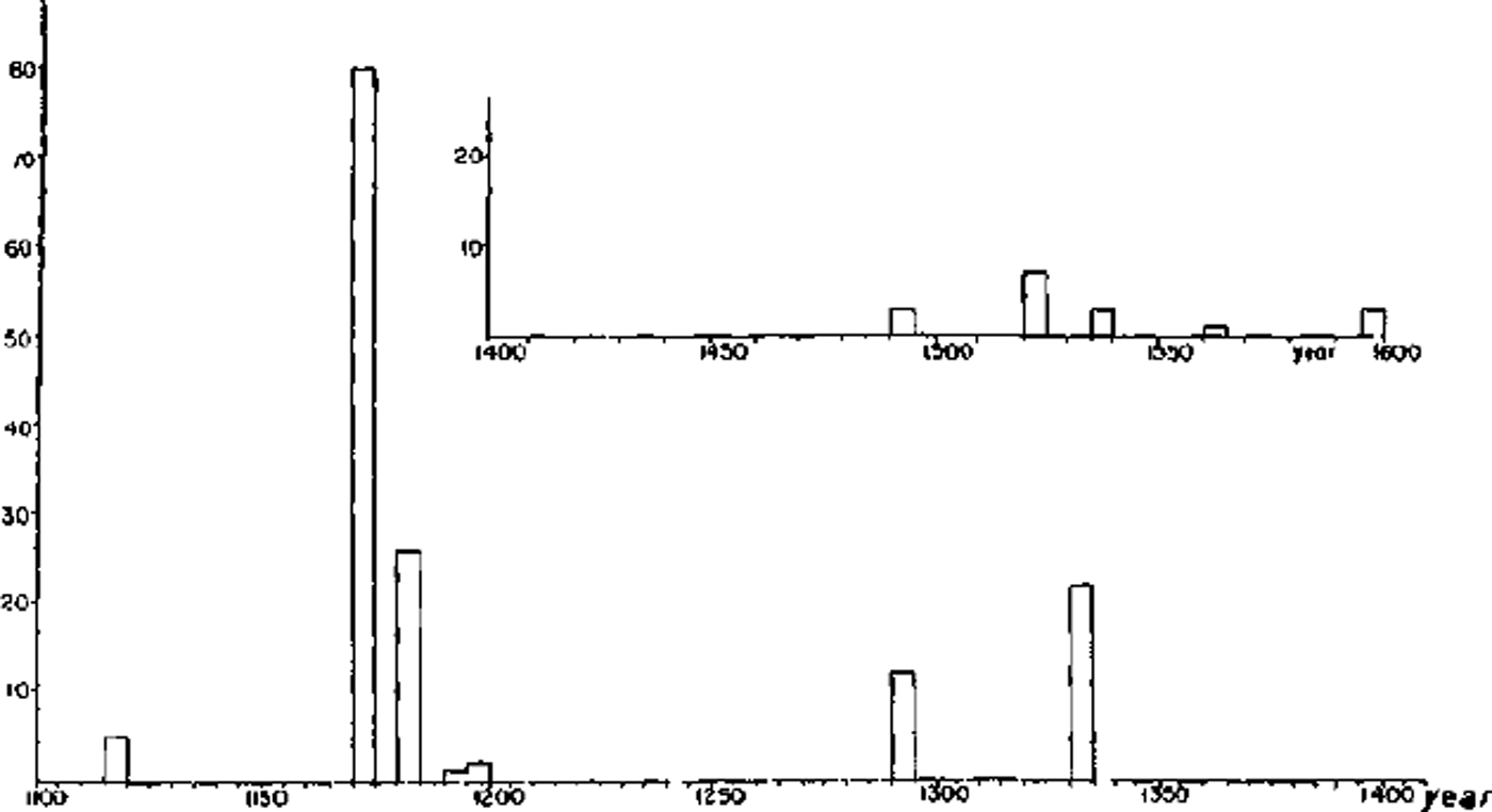
Fig. 2. Reported avalanche fatalities in Iceland by 5 year periods from 1118 to 1600.
Since 1600 the average number of avalanche deaths caused by one accident has been 1.9. When travellers were killed, the average number of deaths was 1.2, but 3.0 when avalanches killed people on farms and 11.3 in the villages. During the twentieth century, roughly 50% of people caught by avalanches have survived. The highest number of deaths by one avalanche was reported in 1613 when 50 people were killed, near Siglufjördur, while walking to church for worship (Fig. 1). The highest recorded number of deaths per year was 80 people in 1171.
On average two people per year out of 100 000 inhabitants have been killed by avalanches in Iceland. Figure 4 shows the number of avalanche victims out of 100 000 inhabitants since the year 1600. The cumulative curve illustrates how the avalanche hazard has become an ever increasing threat to lives from 1700 to about 1920. The slope of the cumulative curve has decreased from 1920 to 1960. This is partly due to favourable snow conditions. Further, from experience, farmers and fishermen have learned to avoid the avalanche sites. Farms have been moved from dangerous to safer sites and winter grazing of sheep in mountain areas has been reduced. The present threat to lives in Iceland is most serious in a few of the expanding fishing villages and in areas of increasing winter-sport activities. Although the present century has seen a comparative reduction in avalanche victims, the damage to roads, bridges, power and telephone lines is ever increasing.
Distribution of avalanches through the year
Snow avalanches have been reported in Iceland in all months except June and July. Figure 5 illustrates the distribution of avalanches throughout the year. Most avalanches fall in February and the damage to dwelling houses has a maximum in this month. Deaths by avalanches show two maxima. The maximum in December is due to increased travel during Christmas time. The maximum in February coincides with maximum avalanche activity and increased travel due to longer days. All travel north of lat. 65° N. was at a minimum in January. In previous centuries there was much travel to the coastal fishing villages in February. The number of deaths is higher in December than in February. In February, mainly grown-up men travelled but many children and old people travelled in December.
Avalanche areas in Iceland
The inhabited areas of Iceland are coastal lowlands or deep fjords and steep valleys. Several mountain ridges radiate from the central Icelandic plateau towards the ocean. These ranges divide the lowlands and separate the valleys. The inhabited areas of Iceland are marked on Figure 6.
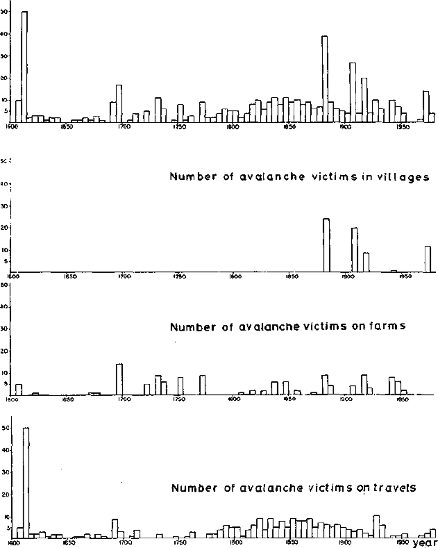
Fig. 3. Recorded avalanche deaths in Iceland by 5 year periods after 1600.
Three main mountain ridges run to the north from the central Icelandic plateau. These ridges are separated by long fjords and, furthermore by wide valleys which are inland continuations of the fjords. One of the ridges lies between Húnaflói and Skagafjördur. The second ridge, called Tröllaskagi, runs between Skagafjördur and Eyjafjördur. This is one of the highest ridges in Iceland with several mountain peaks rising above 1300 m. At the lower levels the mountains are relatively smooth but they are rugged and irregular higher up. The third main ridge runs between Eyjafjördur and Fnjóskadalur. Numerous glacially eroded side valleys trend in an east–west direction and have been cut into the main valleys which run northwards. The landscape in the north is mostly of an alpine character and very rugged. But at the heads of the deepest valleys the mountains have fairly flat summits.
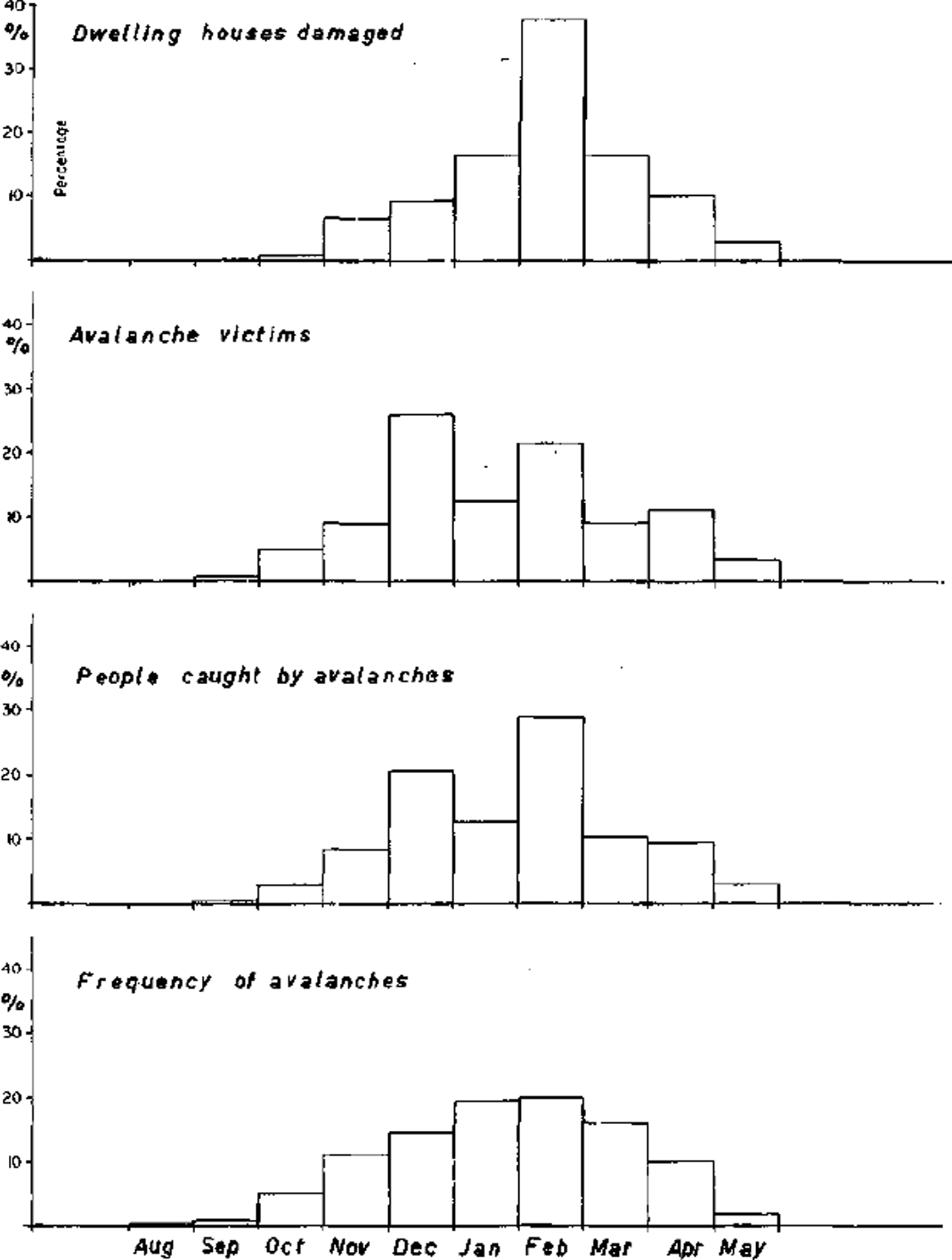
Fig. 5. Distribution of avalanche activity and avalanche hazard by months in Iceland.
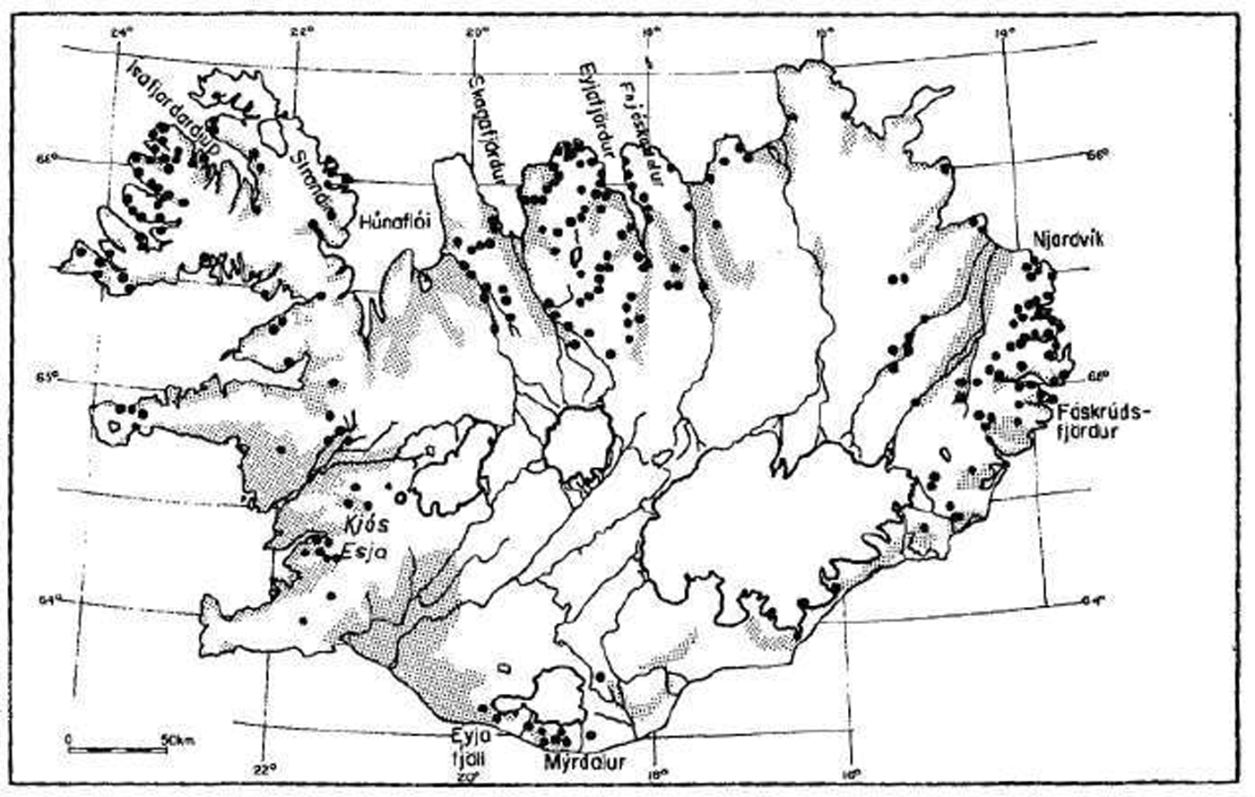
Fig. 6. Location of places where avalanches have been reported to cause damage or deaths. The inhabited areas of Iceland are slippled.
The inhabited districts are mainly in the valleys where the farms usually lie in a single row along the mountainsides. Furthermore, the fishing villages, Siglufjördur and Ólafsfjördur, have serious avalanche problems (Fig. 1).
East coast
About 25% of all fatal avalanches have been recorded in eastern Iceland. A number of mountain ridges trend eastward between the narrow fjords. The landscape is rather similar to that of the north-west peninsula. The mountain ridges are sharper and the summits are not flat but jagged and form a row of separated peaks. The accumulation of snow by wind transport is usually lower than in the north-west peninsula. The east–west trending ridges are separated from the central highlands by north-south trending valleys (except east of Vatnajökull). Many of the fjords are inhabited. The habitation is mostly concentrated in villages and a few neighbouring farms as in the north-west peninsula. The main hazard areas are situated in the fjords between Njardvík and Fáskrúdsfjördur (Fig. 6).
Mýrdalur and Eyjafjöll
This area is an agricultural district and accounts for about 2% of all reported avalanche deaths in Iceland.
Kjós and Esja
About 2% of all deaths by avalanches have been recorded in this area (Fig. 1). Avalanches have caused damage to farms. Recently, this area has been used increasingly as a recreational area by people living in Reykjavík. In the future special attention should be paid to the avalanche hazard in the ski areas south-east of Reykjavík (Bláfjöll, Hengill, and Jósefsdalur).
In southern and south-western Iceland, the main snow-drift direction is from the east and the most dangerous avalanche slopes face either west or south-west. This applies to the Mýrdalur and Eyjafjöll area as well as to Kjós and Esja (Fig. 6).
Other areas
About 10% of reported deaths in Iceland have been located in various parts of western Iceland.
Starting zones
The commonest starting zones for avalanches are in gullies and on slopes beneath rock walls. According to preliminary results, 75% of all starting zones for major avalanches are on slopes from 30° to 40°. Slopes steeper than 45° and less than 25° seem to be rare.
Climatological conditions
Cyclonic activity is very high around Iceland. The weather is characterized by alternating invasions of cold polar air masses of tropical origin. Depressions, which move north-east between Iceland and Greenland, bring relatively mild and rainy weather. But depressions which pass south of Iceland bring relatively cold polar air from the north. The local weather is highly influenced by the central highlands.
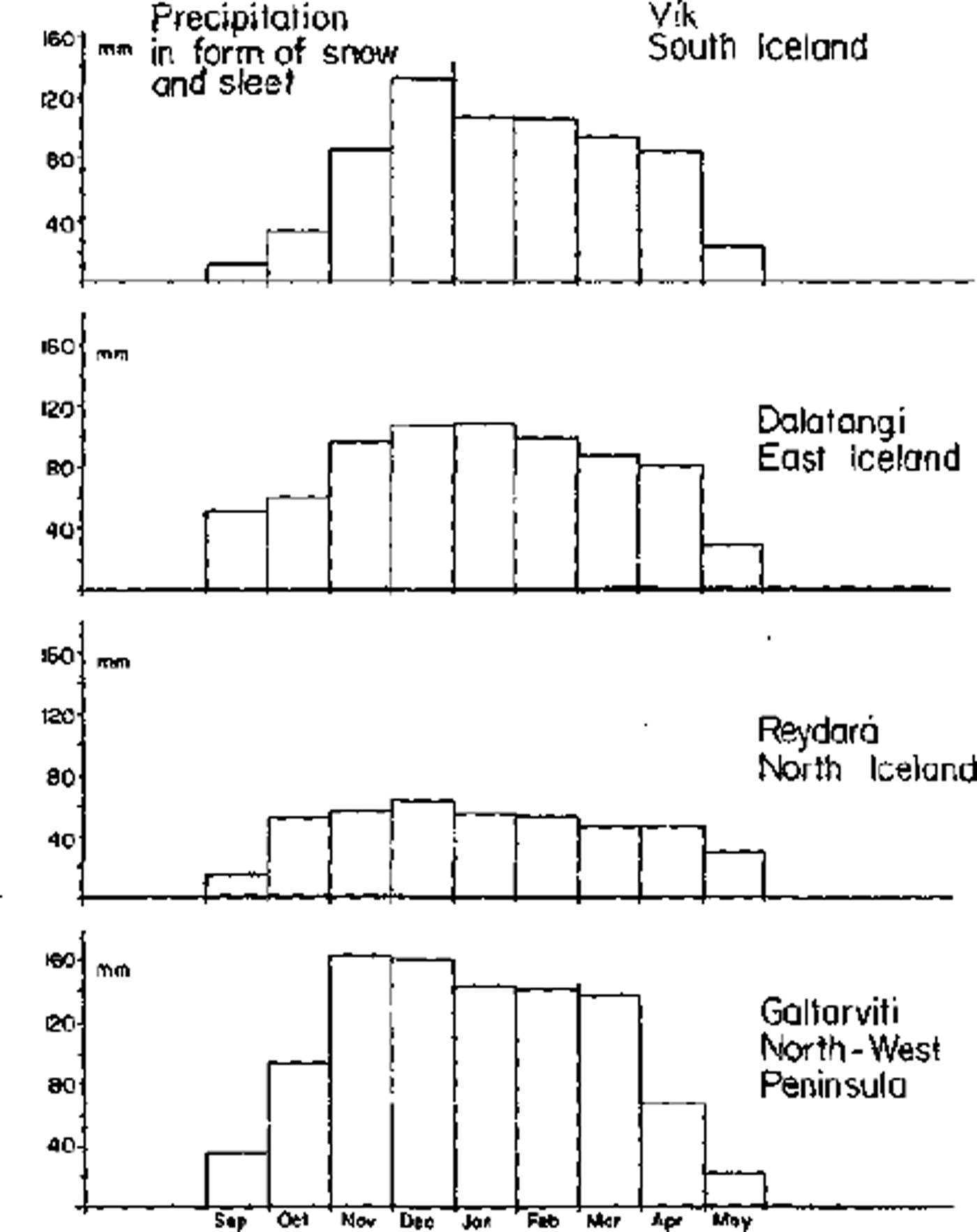
Fig. 7. Snow climatological data for the various parts of Iceland. Distribution by months of precipitation in the form of snow and sleet at four coastal meteorological stations (see Fig. 1).
Snow cover in Iceland
Winters are long but relatively mild. The northern and eastern districts of the country are usually covered by snow from September to the middle of May. The southern part of the country is usually free of snow from April to October. Thaws are frequent in all winter months and the snow cover is very variable, especially at low altitudes in the south. Figure 7 and Table I illustrate some of the snow climatological data for various parts of Iceland. In northern Iceland over 80% of all precipitation from November through April falls as snow. In southern Iceland the amount is about 50% for the same period. The total annual amount of snow is highest in the north-west peninsula and the eastern fjords, although the total annual precipitation is highest in the south.
Table I. Climatological data for four coastal stations in Iceland for the period 1970–77
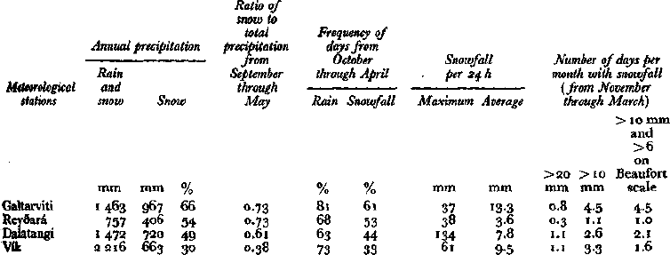
Precipitation is frequent in Iceland but usually not heavy, although more than 100 mm in 24 h have been recorded in the southern and eastern parts of the country. Snowfall is most frequent in the north-west peninsula but at the same time the maximum intensity is lowest. The highest daily rates of snowfall are observed in the eastern fjords and the south.
Wind directions are very variable in Iceland. However, directions from the sector northeast to south-east are most frequent because the main tracks of the depressions lie close to the southern coast of the country. Snow drift is mainly accompanied by cold winds from the north to north-east. However, in the southern part of Iceland northerly winds have usually lost most of the precipitation over the central highlands. But, when easterly winds bring snow, drift is quite frequent. High wind speeds are common in Iceland. Wind forces over 9 on the Beaufort scale on the average occur for 1–3 d during each winter month. The combination of high wind speed and moderate snowfall (> 10 mm d−1) is most frequent in the north-west peninsula. The combination of extremely high wind and heavy snowfall is more frequent in the eastern fjords and in the south.
Area-wide forecasts of avalanche hazard
Research on avalanche forecasting is in the initial stage in Iceland. Local forecasts have not been worked out so far. Some results can be reported on area-wide forecasts.
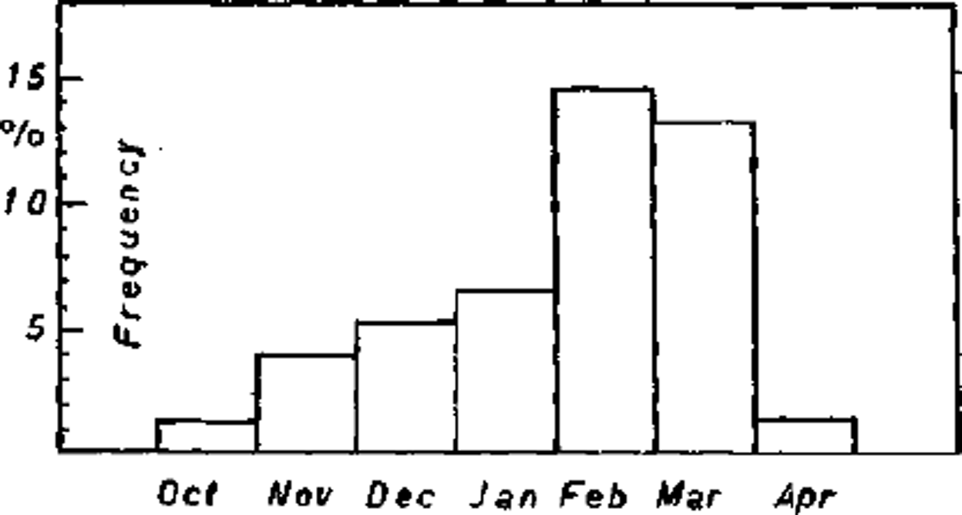
Fig. 8. Frequency by months of avalanche cycles in Iceland after 1900.
Most avalanches in Iceland fall in "avalanche cycles", say 80–90%. In a period of a few days a large number of avalanches fall in the avalanche-hazard areas which are described above. During the present century major distinct avalanche cycles have occurred in 40% of all years, one to three cycles per year. The frequency by months of these cycles is shown in Figure 8. The above-mentioned causes of all the main avalanche cycles in the present century have been studied. Storm plots were drawn for five to eight meteorological stations inside and around each avalanche area (Fig. 9). All the cycles showed common characteristics which preceded critical loads of dry snow. Dry-snow avalanches start to fall in the north-west peninsula, mid-Northland, and eastern fjords when the following hazard limits are reached:
(1) 4–6 days of north to north-east winds of increasing strength from 6 to 10 on the Beaufort scale.
(2) The snowfall is from 15 to 25 mm d−1.
(3) The air temperature is slightly below freezing.
A typical synoptic weather pattern is associated with the avalanche cycles. A depression moves northward close to Iceland and slows down or becomes almost stationary over the sea between Iceland and Norway. This is combined with a high-pressure area over Greenland. The result is a persistent northerly blizzard for a week with heavy snowfall (Fig. 10).
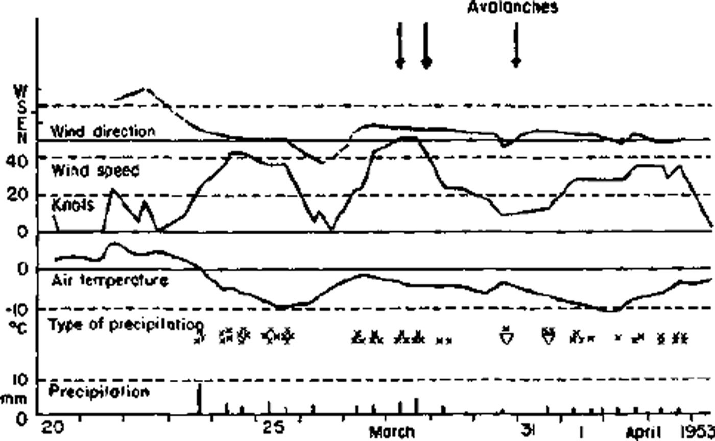
Fig. 9. A storm plot for a meteorological station (Kj¨rvogur, north-west peninsula) before and during an avalanche cycle in the north and north-west peninsula.
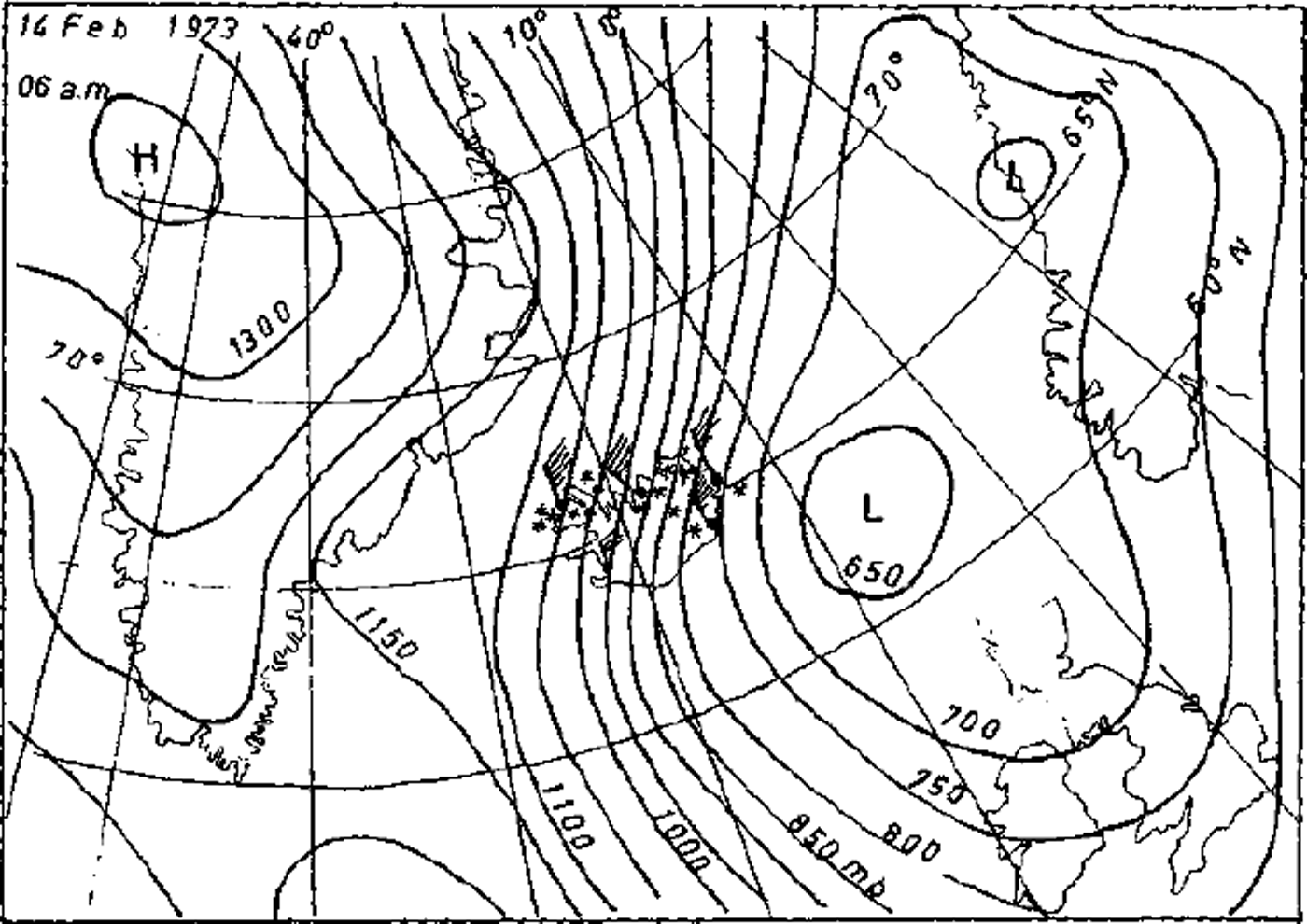
Fig. 10. Typical synoptic condition which triggers a major avalanche cycle in the north, the eastern fjords, and the north-west peninsula. The surface weather map for 14 February 1973.
Wet-snow avalanches occasionally fall after heavy and prolonged (>20 mm for 12–24 h) rainfall on very large amounts of snow in the mountains. Such avalanche cycles are not common in Iceland but they have occurred several times in the eastern fjords and have also been reported in mid-Northland. Wet-snow avalanche cycles may occur when depressions reach their maximum intensity and slow down south of Iceland, and warm Atlantic air invades the country causing thaws and rain in the wintertime.
Concluding remarks
The long record of avalanches in Iceland is of great historical interest and defines the avalanche-hazard areas in the country. The description of the avalanche activity and the climatic conditions gives a background essential for scientific studies of individual slide paths and local avalanche forecasting.


