Hostname: page-component-586b7cd67f-t7czq Total loading time: 0 Render date: 2024-11-27T11:16:34.417Z Has data issue: false hasContentIssue false

I. SITES EXPLORED 1. WALES

Published online by Cambridge University Press:  24 November 2023
Rights & Permissions [Opens in a new window]

Abstract

Type
Roman Britain in 2022
Copyright
Copyright © The Author(s), 2023. Published by Cambridge University Press on behalf of The Society for the Promotion of Roman Studies

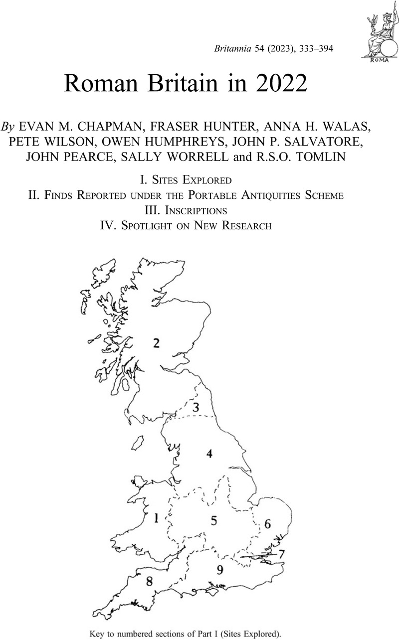
Key to numbered sections of Part I (Sites Explored)

Please note that only the most significant sites and discoveries for each region are included here; for further information, see the supplementary material for each region, available at https://doi.org/10.1017/S0068113X23000260; https://doi.org/10.1017/S0068113X23000272; https://doi.org/10.1017/S0068113X23000284; https://doi.org/10.1017/S0068113X23000296; https://doi.org/10.1017/S0068113X23000302; https://doi.org/10.1017/S0068113X23000314; https://doi.org/10.1017/S0068113X23000326; https://doi.org/10.1017/S0068113X23000338; https://doi.org/10.1017/S0068113X2300034X; https://doi.org/10.1017/S0068113X23000351

BLAENAU GWENT

(1) Aberystruth, Bryn Maen Platform (SO 20814 09878): excavations of an oval platform, 10 m by 8 m, aligned north-west to south-east, cut into on the south-western slopes of Twyn Carn Canddo, produced no evidence for structures and finds were restricted to moderate amounts of charcoal. This was, however, sufficient to demonstrate that the platform was used for charcoal-burning and was not a prehistoric house platform. Radiocarbon dating of charcoal samples demonstrated that the earliest phase of use of the site was Roman, dating to a.d. 210–345 (95.4 per cent probability).Footnote 1 The site probably represents small-scale civilian industrial activity. The date range is comparable to the civilian industrial activity at Caergwanaf and Monmouth, and is probably best seen in that context. It is the only securely dated Romano-British site in Blaenau Gwent.Footnote 2

CARMARTHENSHIRE

(1) Carmarthen, Land between 113–117 Priory Street (SN 4166 2042): an excavation and watching-brief of an area in the centre of the Roman town, immediately to the north of the main east–west road,Footnote 3 revealed intensive occupation from the mid-first century through to the late fourth century a.d. The Romano-British features excavated included the remains of fourteen buildings, two phases of metalled street surface, ovens, drying kilns, pits, post-holes, stake-holes, and floor surfaces. The earliest phase of activity, contemporary with the occupation of the fort, to the west of the town, saw three buildings constructed. During the early to mid-second century, the site was densely occupied, with at least five buildings constructed and used for both domestic and industrial, and/or commercial purposes. The largest of the buildings may have served an official function. This building continued in use into the next phase when there were two other buildings: one domestic and one that appears to have served both as a pottery shop and a bakery, with a bread oven located outside. This building appears to have been destroyed by fire in c. a.d. 170. Large quantities of burnt grain were found within the building. The other two buildings continued in use into the third century, during which three further buildings were constructed. Fourth-century activity appears to have been lower; most of the features dating to this phase were stake-holes, which belonged to five separate groupings and may suggest a focus on industrial or manufacturing processes rather than domestic or commercial activity. Only one new building was constructed.Footnote 4

(2) Eglwyscummin, Yet Wen (SN 1860 1336): a geophysical survey provided a complete plan of the enclosure first identified as a cropmark from an aerial photograph, although it survives as a low earthwork. It confirmed the presence of a single bank and ditch forming a distinctly square-shaped enclosure with well-rounded corners, c. 38 m north–south by 40 m east–west, enclosing an area of 0.05 ha, with an entrance located mid-way along its western side. Faint, internal features were detected but nothing of any significance outside the enclosure. The site can be interpreted as a Roman fortlet or a late Iron Age/Roman defended settlement.Footnote 5

(3) Whitland, Spring Gardens (SN 2076 l690): excavation recorded a Romano-British farmstead, with possible late Iron Age origins. A rectangular ditched enclosure enclosed an area of c. 0.2 ha, with a single entrance to the east. Within the enclosure evidence for domestic as well as metal working activity was recorded. It appears the site fell out of use by the mid-second century.Footnote 6

CEREDIGION

(1) Capel Bangor (SN 647 798): a temporary camp has been found on the floor of the Rheidol valley, some 1.2 km south-east of the fort at Pen Llwyn. Only the north corner of the camp is visible together with some 250 m of the north-west and 300 m of the north-east sides; the remainder having been lost to river meanders, although there are hints of a return on the south, some 500 m distant, together with an internal sub-division. No gates are visible. The defences enclose a minimum of 7.5 ha, with a possible maximum of 15–16 ha. The camp is particularly significant insofar as it is the first to be recorded west of the Cambrian Range and only 7 km from the coast. With the newly discovered 13 ha camp at Pont Rhydgaled, some 17 km to the east, it is possibly indicative of an army pushing west from the upper reaches of the Severn, and thence the upper Wye, over the watershed to the valley of the Rheidol and ultimately Cardigan Bay.Footnote 7

(2) Cwmystwyth, Penparc, (SN 7970 7400): a magnetometer survey of the riverside field on the edge of the Ystwyrh floodplain revealed horseshoe-shaped anomalies reminiscent of the Roman charcoal-burning site at Banc Tynddol to the west.Footnote 8 On excavation only one of these anomalies proved to be a charcoal clamp base; the more broken-up yet stronger positive anomaly 10 m to the west of this was apparently related to ironworking. Smithing slag including several broken-up smithing hearth bases was found associated with a charcoal-rich layer at a depth of 200 mm in one trench, and from a test-pit came a small piece of bloomery tap slag.Footnote 9

CONWY

(1) Caerhun, coin hoard (SH 79 72): a Severn Valley ware jar containing 326 denarii and 2407 radiates was discovered 85 m to the east of an apsidal structure, which has previously been tentatively identified as a temple dated to the third century a.d.Footnote 10 The coins range in date from 32 b.c. to c. a.d. 270 and represent 49 different rulers. Most of the coins appear to have been placed loose in the pot, but 405, all silver and mostly earlier, up to a.d. 250, were held in two leather bags. These leather bags were positioned on top of the other coins. The coins were excavated from the pot a layer at a time. The composition of the coins in each layer showed some small differences. A higher proportion of the coins in the uppermost layer were later in date than in the lower layers. Coins of Postumus were present in large numbers in every level. The positioning of the latest coins in the hoard near the top of the pot, and the earliest near the bottom, ignoring the contents of the two bags, suggests that the unbagged coins may have been added to the pot on multiple occasions over a period of time. The presence of coins of Postumus throughout the hoard, however, indicates that the accumulation of the non-bagged coins did not occur before a.d. 260.Footnote 11

MONMOUTHSHIRE

(1) Caerwent (ST 47 92): 99 Roman copper-alloy coins dating to the period a.d. 260–378 were found in two distinct groups in the same field; unfortunately, the finders did not record which coins came from which group.Footnote 12 Many of the coins are in poor condition, making precise identification and dating impossible for some. The coins comprise 15 radiates, 62 nummi and 22 unidentified coins, either radiates or nummi. The latest identifiable coins were struck during the Valentinianic period, a.d. 364–378, comprising 39 per cent of the total, suggesting that the coins were deposited during or soon after this period. A geophysical survey revealed several archaeological features, including an enclosure ditch surrounding a trapezoidal area in which there were traces of a possible roundhouse.Footnote 13 All the coins were found outside the enclosure. The wood at the top end of the field contains further surface evidence of a settlement or religious site.Footnote 14

(2) Llantrisant Fawr (ST 38 97): a hoard of eight Iron Age and Roman vessels, two complete and six fragmentary. The remains of two stave-built wooden tankards and a bucket, with copper-alloy fittings; a copper-alloy bowl; cauldron; strainer; and two trullei have been identified. The vessels appear to have been buried as a group around the time of the Roman conquest, in the second half of the first century a.d.Footnote 15

POWYS

(1) Llangamarch, (a) Caerau (SN 876 404): aerial reconnaissance has shown that the enigmatic earthwork complex is a fort of two phases. The south-west corner of the Period 1 fort, of unusually obtuse form, and most of its south-west side, is well defined by parching as a rampart and two ditches. The south-east corner has been eroded by a stream. Part of the north-west side is also visible, but the remainder of the circuit is masked by field boundaries and the overall size is difficult to determine, with possible estimates ranging from 4 to 5 ha. Some 30 m to the north-east of the south-west defences of the Period 1 fort the parch marks of a triple ditch system define the defences of a Period 2 fort whose south-west rampart and north-west corner is encapsulated in modern field banks. LiDAR data shows what may be the south-east defences of this reduced fort with the further possibility of an annexe on its north-east side. If such is the case, then this reduced fort may be of the order of 1.5–2 ha in extent. This complex lies 2.5 km to the south-east of the Roman road linking the forts at Caerau (Beulah) and Llandovery and 3 km from the roadside fortlet at Abererbwll (SN 845 9415). By implication both forts are likely to belong to an early campaigning phase, their site being eschewed in favour of that of the fortlet at Abererbwll when a decision was taken to link the forts at Caerau (Beulah) and Llandovery by a road whose course offered a much more expansive view.

About a kilometre south of the fort (SN 877 397), LiDAR images show the faint earthwork of a camp. Although disturbed by a forestry plantation the south-east corner survives well and the entire length of its southern side may be traced for 535 m. Elements of its west and east sides are also visible together with a gate provided with an internal clavicula on the former. The surviving defences suggest that the camp encompassed an area of at least 20 ha.Footnote 16

(2) Maes-Mawr, Talybont-on-Usk (SO 120 225): aerial reconnaissance recorded the cropmark of a temporary camp situated on the valley floor at the confluence of the Usk and the Caerfanell. The rounded south-west corner is well defined and while the north-west corner is lost beneath housing, much of the south and west sides are visible, indicating that the camp was aligned north-west by south-east and enclosed 11.5 ha. No gates are visible, while an east–west ditch suggests that the camp may have been sub-divided at some stage.Footnote 17

(3) Pont Rhydgaled (SN 834 828): a search of Welsh Government LiDAR cover discovered a temporary camp (fig. 1) occupying a ridge at the very uppermost reaches of the Wye valley, with the river immediately to its east, and only about 1.5 km north-east of the small fort at Cae Gaer. The camp is rectangular with dimensions of 417 m east–west by 311 m north–south and encloses 13 ha. The north-west and south-east corners are obscured by forestry plantation; otherwise the rampart is well defined and the site of the north, west and east gates, each provided with an internal clavicula, are visible indicating that the camp faced east. Its discovery, coupled with that of the camp at Capel Bangor 17 km to the west, is highly suggestive of a campaigning route west from the upper Severn valley around Caersws, following that river valley with a possible camp at Dolwen (SN 9914 8518) near Llanidloes,Footnote 18 and thence the upper Wye towards Cardigan Bay.Footnote 19

FIG. 1. Pont Rhydgaled. Temporary camp LiDAR image. (© Crown Copyright)

(4) Three Cocks, Aberllynfi Roman fort (SO 172 376): aerial reconnaissance recorded the cropmarks of a previously unrecorded fort some 250 m north of the fort at Gwernyfed Park.Footnote 20 The parch marks of its street grid encompass an area of some 220 m by 130 m, the south-east side being especially well defined by the cropmark of a substantial ditch c. 5 m wide. The fort appears to enclose an area of c. 3 ha and was aligned north-east by south-west. It survives largely intact beneath arable with only its north-east side obscured by housing. The unusually wide ditch, on the south-east, which has no visible entrance gap, is a feature more in keeping with the dictates of later Roman fortification, however, there is nothing in the visible street grid to suggest that the site is anything other than an early fort.Footnote 21

SUPPLEMENTARY MATERIAL

For supplementary material for this article please visit https://doi.org/10.1017/S0068113X23000260

Footnotes

Edited by PETE WILSON

References

1 (SUERC-105510). Funded by the Community Archaeology Radiocarbon Dating (CARD) Fund administered and funded by Archaeological Research Services Ltd and the Scottish Universities Environmental Research Centre's radiocarbon dating laboratory.

2 Part of the Cwm Celyn Valley Hidden Landscapes Project managed by the Aberystruth History and Archaeology Society with funding from the Heritage Lottery Fund. F. Olding sent information.

3 H. James, Excavations in Roman Carmarthen 1978–1993 (2003).

4 Work by Archaeology Wales for Bro Myrddin Housing Association prior to and during redevelopment for residential dwellings (Archaeology Wales Report No. 2146). R. Philp sent information.

5 Work by C. Enright of Dyfed Archaeological Trust, using a fluxgate gradiometer, grant aided by Cadw (DAT Report No 2021-07), PRN 3815.

6 Work by C. Enright, F. Murphy and P. Poucher of Dyfed Archaeological Trust, on behalf of Langdale Western Ltd, in advance of a housing development. (DAT Report No 2019-48), PRN 118129.

7 The site was discovered by B. Gethin on Bing Aerial Photographs. Information provided by T.G. Driver and J.L. Davies.

8 Andrews, B., Timberlake, S., Craddock, B., Gilmore, A., Pickin, J., and Roseveare, M., ‘A Romano-British Charcoal Production Site at Cwmystwyth, Ceredigion: Archaeological Investigations at Bank Tynddol 2017–19’, Archaeology in Wales 59 (2019), 61–2Google Scholar.

9 Work by P. Andrews, S. Timberlake, B. Craddock, A. Gilmour, and J. Pickin (Early Mines Research Group) and A. and M. Roseveare (TigerGeo Ltd).

10 NPRN 404665.

11 Treasure Case Wales 19.01. To be acquired jointly by Llandudno Museum and Amgueddfa Cymru-Museum Wales. A. Willis provided information.

12 The field has also produced a hoard of siliquae: see Britannia 53 (2022), 404.

13 Work by Amgueddfa Cymru-Museum Wales.

14 Treasure Case Wales 19.36. To be acquired by Amgueddfa Cymru-Museum Wales. Alastair Willis provided information.

15 Treasure Case Wales 19.29. To be acquired by Amgueddfa Cymru-Museum Wales.

16 Information provided by J.L. Davies and T.G. Driver.

17 Work by the RCAHMW. Information provided by T.G. Driver.

18 See J.L. Davies and R.H. Jones, Roman Camps in Wales and the Marches (2006), 152.

19 Information provided by T.G. Driver and J.L. Davies.

20 For the fort at Gwernyfed Park, see Britannia 51 (2020), 124.

21 Work by the RCAHMW. NPRN 309374. Information provided by T.G. Driver and J.L. Davies.

Figure 0

FIG. 1. Pont Rhydgaled. Temporary camp LiDAR image. (© Crown Copyright)

Supplementary material: File

Chapman supplementary material

Chapman supplementary material

Download Chapman supplementary material(File)
File 133.1 KB