Hostname: page-component-cd9895bd7-gvvz8 Total loading time: 0 Render date: 2024-12-30T06:13:47.616Z Has data issue: false hasContentIssue false

What haven't we found? Recognising the value of negative evidence in archaeology

Published online by Cambridge University Press:  21 June 2022

Roger Thomas*
Affiliation:
School of Archaeology, University of Oxford, UK
Timothy Darvill
Affiliation:
Department of Archaeology and Anthropology, Faculty of Science and Technology, Bournemouth University, UK
*
*Author for correspondence ✉ [email protected]
Rights & Permissions [Opens in a new window]

Abstract

Large-scale development-led archaeology has changed the very nature of archaeological datasets. In addition to the familiar positive evidence of structures and deposits, there is now a wealth of ‘true-negative’ evidence: the confirmed absence of archaeological remains. Making good use of such data presents a challenge and demands new ways of thinking. Using case studies based on recent developer-led work in the UK, the authors suggest that focusing on ‘fingerprints’ of past human activity at a landscape scale provides a useful approach. The results argue in favour of changes to existing recording systems, as well as the need to integrate more fully both positive and negative evidence in archaeological interpretation.

Type
Research Article
Copyright
Copyright © The Author(s), 2022. Published by Cambridge University Press on behalf of Antiquity Publications Ltd.

Introduction

Suggesting to an archaeological readership that ‘finding nothing’ can be interesting might seem surprising. Here, though, we argue that ‘negative’ evidence is actually an important category of archaeological information, hitherto largely overlooked. A fuller and more systematic recognition of the value of negative evidence represents a potentially significant advance in the use of archaeological information as a whole. It enables us to see the familiar kinds of ‘positive’ evidence in a different light, allowing more rounded and soundly based interpretations, and raising new research questions. ‘Finding nothing’ (true-negative evidence) can be just as important as ‘finding something’ (true-positive evidence); both should contribute in equal measure to understandings of the past.

The issue has been highlighted in recent years by the results of large-scale development-led archaeology in many parts of the world (e.g. Bofinger & Krausse Reference Bofinger and Krausse2012; Darvill et al. Reference Darvill2019). This has given us, often for the first time, large bodies of reliable negative evidence: that is, places where archaeological remains, or those of particular periods or kinds, have been systematically sought and been shown definitely not to be present. Our case studies below are all drawn from the United Kingdom, but the principles they illustrate are widely applicable.

Understanding and using negative evidence has broad relevance. It applies, for example, to the interpretation of distribution maps (Hodder & Orton Reference Hodder and Orton1976: 27–29) and is critical for the predictive modelling of deposits (Carey et al. Reference Carey2018) and archaeological sensitivity (Darvill & Gerrard Reference Darvill and Gerrard1994: 138–44). Here, we concentrate on sites and landscapes, and on regional histories of settlement and land-use, as illuminated by evidence from large-scale excavations. Our focus reflects the broad and continuing theoretical and empirical interest in ‘landscape’ in archaeology (e.g. Ingold Reference Ingold1993; Bruno Reference Bruno2008; Gosden et al. Reference Gosden2021).

Traditionally, excavations were designed to learn more about remains whose existence was already known or suspected. In that situation, ‘finding nothing’ was a disappointment, and counted as a failure. The aims of development-led archaeology are very different. Study areas are generally defined by non-archaeological factors, such as the extent of the proposed development project, and the primary objective of the initial work (assessment and evaluation) is to discover what structures and deposits, if any, are present across the entire area. In that context, ‘negative’ results are just as important as ‘positive’ findings (and generally more welcome to the developer). Because of the scale of some developments, this approach has given us large bodies of negative evidence. Although acquired for the purpose of archaeological heritage management, this evidence can also be used to advance wider understandings of past societies and their use of space at a landscape scale.

What do we mean by negative evidence?

The aphorism ‘absence of evidence is not evidence of absence’ applies widely in archaeology, in which detecting or revealing things that are normally hidden plays a large part. This is particularly an issue in the interpretation of spatial information. Here, it is necessary to assess the extent to which an archaeological distribution simply reflects the pattern of investigations, or the varying visibility of archaeological remains in different environments, rather than the original distribution of ancient material.

A widely used phrase is ‘blank area’—an informal term often applied rather loosely to areas in which little or nothing has so far been discovered. In a way, the notion of ‘blank areas’ neatly encapsulates the problem. Is an area really ‘blank’ in the sense of being truly devoid of archaeological remains of particular types, or does it only appear so because of a lack of archaeological work?

In practice, recognising the presence or absence of archaeological remains is not a binary determination. True-negative evidence is just one of a quartet of possibilities (Figure 1). True-positive evidence is relatively unproblematic and is what most archaeological effort is directed towards. It relates to the discovery of tangible remains, whether or not these were intentionally sought. False-positive evidence is less common. An example might be an apparent feature located through geophysical survey, but which subsequent investigation shows to be natural or non-existent. False-negative evidence arises through a failure to recognise something that is actually there. In the context of development projects, false negatives can be disastrous, as potentially important evidence may be lost or only becomes apparent when construction work has already started. Finally, true-negative evidence is the result of investigating an area using appropriate techniques and genuinely finding no archaeological features, deposits or artefacts.

Figure 1. Four-way outcome matrix for the presence/absence of archaeological remains recorded through fieldwork (figure by T. Darvill).

The relationship between the field techniques used and the confidence that can be assigned to findings is critically important. Some categories of archaeological material, such as lithic scatters and some forms of early medieval activity, for example, may be contained entirely within the topsoil. If that is stripped off mechanically without being sampled, it might wrongly be concluded that the area was unused, when, in fact, the apparently negative result (a false-negative in this case) was the product of the archaeological method rather than a true reflection of the archaeological record.

Also relevant is the matter of visibility. Evidence relating to some activities may exist at such a low level of intensity, or be of such a character, that it can easily escape identification and thus trigger a record of negative evidence. A site may appear to contain no evidence for activity during a particular period, for example, but if charcoal from an artefact-free pit was radiocarbon dated, the pit might be shown to belong to that period. When we talk of ‘negative evidence’ for human activity, what we are really saying is that there is ‘no evidence above the threshold of archaeological visibility’. This point links to the concept of archaeological ‘fingerprints’ (or ‘signatures’), discussed further below.

Some sources of true-negative evidence and its significance

While many forms of archaeological investigation yield true-negative evidence, some are, as suggested above, less reliable than others. Aerial photography and geophysical surveys are two examples. Cropmarks revealed through aerial photography are notoriously capricious. They can appear in some years, or in some types of crops, but not in others, and may sometimes only show up in exceptional conditions, such as a very dry summer. Thus, the absence of cropmarks is not a reliable source of true-negative evidence. Likewise, different methods of geophysical survey produce different results, depending on specific geologies. In the right circumstances, geophysical survey can be a reasonably reliable indicator of ‘absence’ as well as ‘presence’, but caution is needed.

Excavation should, in theory, provide conclusive evidence about what is and is not present. In practice, many older excavations were limited in extent, focused on known monuments, and did not necessarily remove all the archaeological deposits or reach the natural bedrock beneath. Thus, the value of many earlier excavations as a source of reliable true-negative evidence is limited.

In recent decades, this situation has changed radically, with large-scale development-led archaeology commonplace in many parts of the world. In Europe, the Valletta Convention (Council of Europe 1992) and Environmental Assessment regulations (European Commission 2021) help to codify practice. A staged approach is usually followed, in which extensive assessments and evaluations inform decision-making about the development. This allows for a tailored archaeological strategy that promotes preservation where possible and full-scale investigation and recording where it is not.

Major development projects, such as motorways, railways, airports, urban extensions and quarrying, can result in archaeological work on a vast scale, covering tens or even hundreds of hectares, and generating dozens of reports covering everything from initial surveys through to set-piece excavations (Thomas Reference Thomas2013; Darvill et al. Reference Darvill2019: 192–284). This substantial literature contains a lot of true-negative evidence, albeit rarely identified as such or discussed. Although methods vary from country to country, the principles are shared. Here, we discuss three types of development-led work, common in the UK, all of which can yield extensive true-negative results. As noted above, topsoil and subsoil are usually removed mechanically; topsoil sampling through surface collection (fieldwalking) or test-pitting is rare in England (Darvill et al. Reference Darvill2019: tab. 3.15), although both positive and negative evidence is well represented in such contexts (Evans et al. Reference Evans, Tabor and Linden2014). The true-negative evidence from our case studies below must be seen in that light.

Field evaluations

Field evaluations are diagnostic exercises usually carried out to inform decision-making about the nature and design of a development and its authorisation (Darvill et al. Reference Darvill2019: 68–91). The aim is to identify and characterise the archaeological remains within the proposed development area. Most field evaluations examine a 2–4 per cent sample of the development area, using an array of machine-cut linear trenches. Small features, such as postholes or scattered pits, tend to be under-represented in the results of such exercises, whereas large and extensive features, such as enclosures and occupation sites, rarely escape detection (Hey & Lacey Reference Hey and Lacey2001). Field evaluations can also provide extensive true-negative evidence. This is important, because it enables the design of a proposed development to minimise harm to archaeological remains. Two examples illustrate this point.

At Cambourne, Cambridgeshire, in eastern England, an area of approximately 400ha (4km2) was evaluated (Wright et al. Reference Wright, Leivers, Smith and Stevens2009), with trenches covering some 2 per cent of the development area. The report notes that there were very few isolated features, with ditches and pits being closely grouped around a number of settlements, mainly of Iron Age and Roman date. This is important, because it suggests that the settlements existed in an open landscape, with no evidence of boundary ditches or ditched field systems between them. There was little evidence of activity in the landscape before the Iron Age. Moreover, the area was used only for agriculture after the fifth century AD; later settlement was probably located under the sites of nearby modern villages.

Similarly, at Kempsford, Gloucestershire, in the upper Thames Valley, trenches covering a total of 1.8ha, or approximately 2 per cent of the 87ha development area, were excavated in advance of gravel extraction (Taylor Reference Taylor2012). Archaeological features were located, but were unevenly distributed, with the eastern part of the site in particular containing very little. Dating evidence was sparse. Only seven sherds of pottery were recovered from the whole exercise: one medieval and six post-medieval. In an area generally considered rich in Iron Age and Roman occupation, including settlements immediately adjacent to the evaluated area, this negative result is remarkable and demands explanation. This very light archaeological fingerprint probably represents low-intensity land-use, perhaps as long-term open pasture associated with the nearby settlements.

Linear developments

Linear developments, such as roads, railways and pipelines, have a particular value to archaeological interpretation because they provide transects, often extending for tens or even hundreds of kilometres, across a variety of landscape zones. In some cases, the routes traverse areas that have not previously been subject to much archaeological investigation. Information from these schemes can show both where past activities took place and where they did not, and how this changed through time. Three examples illustrate the potential of using positive and negative evidence together.

The M6 Toll Road involved archaeological work at selected locations along a 44km route through the West Midlands (Powell et al. Reference Powell, Booth, Fitzpatrick and Crockett2008). The results were significantly affected by methodological problems, and by a scarcity of artefacts that caused difficulties with dating. Many periods were not represented at all, and long stretches seemed devoid of any significant archaeological remains. For the Bronze Age, only two burnt mounds were recorded—a sharp contrast to what might be expected on similar-sized schemes in some other parts of Britain.

Some projects reveal mainly negative evidence. The report on monitoring works along a 94km gas pipeline corridor across the Pennine uplands of northern England remarks on the general scarcity of remains encountered (Casswell & Daniel Reference Casswell and Daniel2010: 141). Nothing of Neolithic or early medieval date was recorded, and remains of all other periods were very scarce, probably representing the fingerprints of low-intensity activities, such as upland grazing.

By contrast, a gas pipeline running for 318km from Milford Haven in west Wales to Tirley in Gloucestershire revealed a wealth of evidence for all periods (Darvill et al. Reference Darvill2020). Importantly, the distributions were uneven and reveal real differences in patterns of occupation and land-use across time and space. For example, reviewing the evidence for Early Neolithic activity along the pipeline corridor from Milford Haven to Brecon in relation to altitude (Figure 2), it is notable that only two of the 13 sites with evidence datable to the early fourth millennium BC lay on high ground, with the majority being located in the main river valleys and on the coastal plain. Investigations on the higher ground commonly identified activity of other periods, while confirming a real absence of traces of Early Neolithic activity. These patterns are therefore based on reliable positive and negative evidence; in other words, we have real ‘evidence of absence’, as opposed to mere absence of evidence, for Early Neolithic activity on high ground in this region.

Figure 2. Topographic position, by altitude, of Early Neolithic sites (4000–3400 BC) investigated on sections of the South Wales Gas Pipeline (triangles) in relation to investigated sites with demonstrated absence of Early Neolithic activity (open circles) (from Darvill et al. Reference Darvill2020: fig. 4.3; © Cotswold Archaeology, reproduced with permission).

Large open-area excavations

If archaeological remains are to be destroyed by a major development, extremely large areas may be examined in detail, often using a ‘strip, map and record’ strategy. This involves removing the overburden, cleaning the top of the natural and mapping visible features, and then systematically recording and sampling the archaeological deposits represented. In England, such excavations covering 10ha or more have become quite common, with some extending to several hundred hectares (Darvill et al. Reference Darvill2019: 114–17). Moreover, the cumulative results of numerous contiguous investigations carried out over many years, as in the upper Thames Valley (Morrison et al. Reference Morrison, Thomas and Gosden2014), provide detailed archaeological information across areas that are larger than the ‘life-spaces’ within which typical pre-industrial communities lived and farmed.

At Horcott Quarry in Gloucestershire, excavations in 2007 and 2008 examined approximately 10ha (Hayden et al. Reference Hayden2017). Although remains from many periods were identified, everything before c. 800 BC (the Early Iron Age) was at a low level of intensity, with gaps in the sequence (Figure 3). A light scatter of Mesolithic flints in a very restricted area marked the earliest use of the area, after which there was nothing visible until two pairs of pits—probably the remains of single-event ceremonial activity—were dug more than 3000 years later, in the early third millennium BC. Nearly a millennium after that, some pits and a length of ditch were dug alongside a small former stream channel, and, at some point over the subsequent four or five centuries, a burnt mound and waterhole appeared adjacent to the palaeochannel (Hayden et al. Reference Hayden2017: fig. 4.1). It may have been the emptiness of this landscape that provided the ideal conditions for a more intensive colonisation of the area soon after 800 BC. A substantial settlement, comprising at least a dozen round houses and over 130 four-post structures—possibly granaries—was established at this time, with activity continuing to c. 400 BC. Periods of quietude interspersed with intensive activity became the norm over the following 2500 years until the present day, raising questions about where people were living and how the area was being used during periods that generated only negative archaeological evidence.

Figure 3. Open-area excavation at Horcott, Gloucestershire. Pre-Iron Age features are coloured and marked. Later features are shown in outline; before the Iron Age, the central part of the site was completely empty of features (from Hayden et al. Reference Hayden2017: fig. 4.1; © Oxford Archaeology, reproduced with permission).

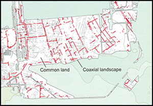
Areas of true-negative evidence within a large excavation may also be of special interest. Work at London's Heathrow Airport Terminal 5 examined 75ha of gravel terrace and located Bronze Age field systems, trackways and settlements, as well as other prehistoric and later remains. The excavators noted that one area of approximately 3ha was curiously devoid of archaeological features. It lay between two Bronze Age field systems of differing character and remained empty throughout the period, despite many changes in the adjacent field systems, settlements and trackways (Figure 4). The excavators suggest that it may have served as common land for a millennium or more (Framework Archaeology 2010: 206). In this case, it was only the scale of the archaeological work that made it evident just how unusual this empty area was within the wider Bronze Age landscape. In smaller-scale work, such an area might have seemed simply archaeologically unproductive, and therefore uninteresting; as such, it would have been omitted from the interpretative narrative.

Figure 4. Open-area excavations at Heathrow Airport Terminal 5. Summary of the recorded Bronze Age features. An empty area of approximately 3ha, lying between two field systems on different alignments, was interpreted as long-term common land (adapted from Framework Archaeology 2010: fig. 3.1; © BAA, Oxford Archaeology and Wessex Archaeology, reproduced with permission).

Many more examples of such ‘true-negative’ evidence can be found in the ever-growing body of reports on development-led archaeological work in the UK and elsewhere.

Interpreting true-negative evidence

The availability of true-negative evidence opens new possibilities for interpretation. It can also lead us to look at our true-positive evidence in new and different ways. Some parts of the world doubtless saw minimal human activity in the past, although the discovery of the body of a Late Neolithic man preserved in ice high in the Italian Alps shows that even very remote places were visited occasionally (Spindler Reference Spindler2001). In other regions, every part of the landscape was used by people from prehistoric times onwards, leaving abundant archaeological traces. In many areas of Britain, ‘finding nothing’ in large-scale fieldwork is now sufficiently unusual to be noteworthy in itself; indeed, this is one of the factors that prompted the current article.

We see true-negative evidence as taking two main forms. The first is where nothing at all is found: a genuinely ‘blank’ area. This is partly a matter of scale and density; the larger the investigation, the more likely it is that something will be found somewhere within the study area (and vice versa). Such areas are rare in Britain.

The second form is where remains of some periods or types are found, but not others. As seen in our examples, identifying areas of land that were empty at particular periods in time is important. But they were not ‘blank’ in the past. They most likely represent areas of pasture, forest, heath, or ‘waste’—economically important but used in ways that leave very limited archaeological traces. Once identified, these areas can be set beside the evidence for contemporaneous settlement sites, enclosed fields, trackways and burial sites—the traditional foci of investigation—to give a much fuller picture of past land-use patterns and settlement structure.

This approach can be applied at both a local level and more widely. The lower Thames Valley, for example, contains extensive Middle Bronze Age field systems. The scale of recent work in the eastern Cotswolds and upper Thames Valley, with some 15km2 excavated or evaluated (Morrison et al. Reference Morrison, Thomas and Gosden2014), shows that such systems really are absent here. This is genuine ‘evidence of absence’, not a product of differential investigation, and is important for understanding regional settlement dynamics in prehistoric southern Britain. As much as anything, it emphasises how not everything occurs everywhere; patterns differ between one area and the next.

Charting long-term patterns of presence and absence is also worthwhile. At Cambourne, the area was little occupied except in the Iron Age and Roman periods. By combining information from multiple investigations, it is possible to chart, in detail, local and regional patterns of colonisation, settlement, use and abandonment through long periods of time. Shifts in the geographical distribution and intensity of population and agricultural production are an important component of the overall processes of social, economic and political change in the past. Achieving a better understanding of these processes offers great potential for new insights into past societies.

We therefore argue that much more attention should be paid to what is not found in particular areas, and how that relates to what is found elsewhere, in other words, a more relational approach to both spatial and temporal variation.

Methodological implications

Using negative evidence and adopting a more relational approach has implications for methodology. First, and most obviously, we need to record and report on archaeological investigations that find nothing, just as we report on those where something is found. Traditional archaeological inventories record monuments and finds, but not negative evidence. In England, the adoption of ‘event recording’—creating databases of what archaeological work (or ‘events’) has taken place, as well as of what was found—provides a structure within which negative evidence can be recorded (see Darvill et al. Reference Darvill2019: 19–20). Nonetheless, until the importance of negative evidence is appreciated, there is a risk that work that ‘finds nothing’ will not be properly reported.

As an example, much previous pipeline archaeology suffers from this problem. Very often, following a programme of prospection, particular locations along a pipeline are selected for detailed investigation. In the final report, however, it is often unclear what level of observation, if any, was carried out on construction work between the areas of formal excavation. Was there an archaeological watching brief as the topsoil along the route was stripped off? Was there any kind of sampling to verify the nature of subsurface deposits? Without this information, it is impossible to know whether or not the areas between the excavated blocks are true-negatives.

Thinking about negative evidence also prompts us to view our positive evidence in a new light. Why was an area used for habitation during two widely spaced periods, but not in between? How was the area being used when it was not inhabited? And why are some things that should be there apparently missing? The distribution of Anglo-Saxon burial sites of c. AD 600–850 in England, for example, is considerably wider than that of contemporaneous settlements. This suggests that settlements in some areas took forms that are currently archaeologically invisible to us (Blair Reference Blair2018: 29 & fig. 5). The extent of development-led work is now sufficient to indicate that this is a real pattern, prompting us to ask: why are these settlements not visible to us?

The notion of formation processes is helpful here: cultural and natural transformations, pre- and post-deposition, that determine what exists to be found (Schiffer Reference Schiffer1976). What is actually found, though, is a function of our methods. Development-led archaeology uses a relatively limited range of field techniques, and the kinds of positive results produced are now fairly predictable. Do we need to devise new methodologies aimed at finding things that are likely to exist in some form, but which we are currently not seeing?

Wider considerations

The discussion above opens wider issues. In starting to think about past human activities in apparently blank areas, the concept of archaeological fingerprints comes to the fore. Different types of human activities leave particular patterns of evidence (e.g. deposits, structures, artefacts and ecofacts), which can be brought together as a kind of ecology (Smith Reference Smith1984). In areas of extensive and low-level use, such fingerprints may be hard to spot but are nonetheless distinctive. Ploughed land may be characterised by scatters of farmyard manuring waste, distinctive chemical signatures, and occasional objects, such as dress-fittings, lost by those working the land. Pastures and meadows will have seen less intensive human activity than cultivated land, but one might expect occasional artefacts and perhaps traces of ephemeral structures, such as shelters. Forests might have seen little human visitation, leaving only minimal evidence, although woodland activities might leave distinctive traces. These differences merit further elucidation. Earlier work has shown the scope for identifying manuring scatters through fieldwalking (Williamson Reference Williamson1984; Wilkinson Reference Wilkinson1989). Can we establish fingerprints for other types of land use? Archaeological terms such as ‘casual loss’ and ‘background noise’ may be blinding us to the significance of low-level artefact distributions. Similarly, should we be paying more attention to those scattered, undated features that are generally ignored in excavation reports? In short, negative (or very slight) evidence does not indicate an absence of human activity. Rather, it is part of an overall pattern of archaeological fingerprints that represent different forms and intensities of activity and land-use.

The question of scale is also important. Recognising and defining empty areas and ‘absence’ is intrinsically related to scale. They may be seen at a local scale within settlement complexes (Heathrow Terminal 5, above) or adjacent to them (Kempsford), at a regional level (the Thames Valley Bronze Age), or even more broadly. The EngLaId project, covering the period 1500 BC to AD 1100, has illuminated broad, long-term contrasts between an intensively occupied southern and eastern England, and a much emptier north and west (Gosden et al. Reference Gosden2021: 402–404). The latter zone was not completely empty; rather, the probability of ‘finding nothing’ in an area of given size seems much higher there.

Recognising that there were genuinely empty areas in the past enables us to look at results from previous regional and landscape studies through a slightly different lens. Regional surveys, in the Mediterranean for example, have identified broad spatial and temporal patterns of settlement that can be related to demographic change (e.g. Bintliff & Sbonias Reference Bintliff and Sbonias1999). Those patterns are manifested in both positive and negative evidence; even where large-scale ‘true-negative’ evidence from development-led work is currently lacking, our perspective shows the theoretical scope for distinguishing between ‘absence of evidence’ and ‘evidence of absence’, and the value of doing so.

Negative evidence and archaeology as observation

In most sciences, it is standard practice to record, in detail, the way observations are made, because it is fully recognised that how you observe shapes the results obtained. In archaeology, especially in relation to excavation, this practice is not always followed. Basic information about the methods deployed and critical reflections on their application is often lacking from published reports. This can make it difficult to assess the results, especially whether things were really absent or were present but simply missed.

Today, there is an increasingly wide range of multi-scalar observational techniques available for mapping and investigating landscapes, structures, features and deposits. There is also a growing awareness of the need to understand the origins, properties and limitations of the datasets that these approaches provide, and also to evaluate critically the results from past work—what Cooper and Green (Reference Cooper and Green2016: 294–95) refer to as the ‘characterful’ nature of our accumulated body of archaeological information.

For all these reasons, archaeology needs to pay more attention to the relationship between the evidence we possess and the methods used to collect it. A greater focus on true-negative evidence may yet be seen as a significant contribution to the practice of archaeology, and especially of field investigations. It points towards a far more explicitly observational science, in which careful evaluation of the techniques used is seen as a vital underpinning for the interpretation of what is, and is not, found.

Conclusion

Archaeologists love finding things, so finding nothing can be disappointing. Here, however, we argue for the value of thinking more deeply about negative evidence, and especially true-negative evidence as defined above. This is not simply a matter of failing to find things; methods must be rigorous. Combining true-positive and true-negative evidence produces more rounded and more nuanced understandings of the archaeological resource and of past patterns of human activity. The abundance of positive evidence from large-scale development-led archaeology, paradoxically, highlights the value and potential of negative evidence.

Large-scale true-negative evidence is a newly recognised type of archaeological information. Making the most of it will require adjustments to our thinking; it is all too easy to give no thought at all to the significance of negative evidence. Changes to methods and practices will also be required but we believe that these will be well worth the effort. The places where we do not find things, and the things we do not find, are as significant as those we do. Consideration of true-negative evidence can give us valuable new perspectives on our evidence as a whole. We should pay much more attention to what we do not find, odd though this might seem at first sight.

Acknowledgements

The ideas behind this paper have been fermenting for some time but were first brought together in the session ‘What haven't we found? Blank areas and the value of negative evidence’ that we organised for the 2018 Annual Meeting of the European Association of Archaeologists in Barcelona, Spain. Grateful thanks are extended to the contributors and participants at that event for galvanising our thoughts. We also remember with gratitude the late Bob Smith's contributions to many long and detailed discussions about fingerprinting activity areas through archaeological deposits in their landscape context. We are also grateful to the two anonymous reviewers for their valuable comments on a draft of this article.

Funding statement

This research received no specific grant from any funding agency or from commercial and not-for-profit sectors.

References

Bintliff, J. & Sbonias, K.. 1999. Reconstructing past population trends in Mediterranean Europe. Oxford: Oxbow.Google Scholar
Blair, J. 2018. Building Anglo-Saxon England. Princeton (NJ): Princeton University Press. https://doi.org/10.1515/9781400889907Google Scholar
Bofinger, J. & Krausse, D.. 2012. Large-scale excavations in Europe: fieldwork strategies and scientific outcome. Proceedings of the international conference, Esslingen Am Neckar, Germany, 7th–8th October 2008. Brussels: Europae Archaeologiae Consilium.Google Scholar
Bruno, D. 2008. Handbook of landscape archaeology. Walnut Creek (CA): Left Coast.Google Scholar
Carey, C. et al. (ed.). 2018. Deposit modelling and archaeology. Brighton: University of Brighton.Google Scholar
Casswell, C. & Daniel, P.. 2010. Stone was the one crop that never failed: the archaeology of a trans-Pennine pipeline (British Archaeological Reports British Series 526). Oxford: Archaeopress. https://doi.org/10.30861/9781407307398Google Scholar
Council of Europe. 1992. European convention on the protection of the archaeological heritage (revised). Valetta 16.1.1992 (European Treaty Series 143). Strasbourg: Council of Europe.Google Scholar
Cooper, A. & Green, C.. 2016. Embracing the complexities of ‘Big Data’ in archaeology: the case of the English Landscape and Identities Project. Journal of Archaeological Method and Theory 23: 271304. https://doi.org/10.1007/s10816-015-9240-4CrossRefGoogle Scholar
Darvill, T. & Gerrard, C.. 1994. Cirencester: town and landscape. Cirencester: Cotswold Archaeological Trust.Google Scholar
Darvill, T. et al. 2019. Archaeology in the PPG16 era: investigations in England 1990–2010. Oxford: Oxbow.Google Scholar
Darvill, T. et al. 2020. Timeline: the archaeology of the South Wales Gas Pipeline. Kemble: Cotswold Archaeology.Google Scholar
Evans, C., Tabor, J. & Linden, M. Vander. 2014. Making time work: sampling floodplain artefact frequencies and populations. Antiquity 88: 241–58. https://doi.org/10.1017/S0003598X0005033XCrossRefGoogle Scholar
European Commission. 2021. 35 years of EU environmental impact assessment. Luxembourg: Office of the European Union.Google Scholar
Framework Archaeology. 2010. Landscape evolution in the middle Thames Valley: Heathrow Terminal 5 excavations, volume 2. Oxford & Salisbury: Framework Archaeology.Google Scholar
Gosden, C. et al. 2021. English landscapes and identities: investigating landscape change from 1500 BC to AD 1086. Oxford: Oxford University Press. https://doi.org/10.1093/oso/9780198870623.001.0001CrossRefGoogle Scholar
Hayden, C. et al. 2017. Horcott Quarry, Fairford and Arkell's Land, Kempsford. Oxford: Oxford Archaeology.Google Scholar
Hey, G. & Lacey, M.. 2001. Evaluation of archaeological decision-making processes and sampling strategies. Oxford: Oxford Archaeological Unit.Google Scholar
Hodder, I. & Orton, C.. 1976. Spatial analysis in archaeology. Cambridge: Cambridge University Press.Google Scholar
Ingold, T. 1993. The temporality of landscape. World Archaeology 25: 152–74. https://doi.org/10.1080/00438243.1993.9980235CrossRefGoogle Scholar
Morrison, W., Thomas, R. & Gosden, C.. 2014. Laying bare the landscape: commercial archaeology and the potential of digital spatial data. Internet Archaeology 36. https://doi.org/10.11141/ia.36.9Google Scholar
Powell, A.B., Booth, P., Fitzpatrick, A.P. & Crockett, A.D.. 2008. The archaeology of the M6 Toll, 2000–2003. Oxford & Salisbury: Oxford Wessex Archaeology.Google Scholar
Schiffer, M. 1976. Behavioural archaeology. New York: Academic Press.Google Scholar
Smith, R.W. 1984. The ecology of Neolithic farming systems as exemplified by the Avebury region of Wiltshire. Proceedings of the Prehistoric Society 50: 99120. https://doi.org/10.1017/S0079497X00007490CrossRefGoogle Scholar
Spindler, K. 2001. The man in the ice. London: Phoenix.Google ScholarPubMed
Taylor, A. 2012. Kempsford Quarry extension, Kempsford, Gloucestershire: an archaeological evaluation. Reading: Thames Valley Archaeological Services. https://doi.org/10.5284/1018439Google Scholar
Thomas, R. 2013. Bridging the gap? Scale and development-led archaeology in England today. Landscapes 14: 92102. https://doi.org/10.1179/1466203513Z.0000000007CrossRefGoogle Scholar
Wilkinson, T.J. 1989. Extensive sherd scatters and land-use intensity: some recent results. Journal of Field Archaeology 16: 3146. https://doi.org/10.1179/jfa.1989.16.1.31Google Scholar
Williamson, T.M. 1984. The Roman countryside: settlement and agriculture in NW Essex. Britannia 15: 225–30. https://doi.org/10.2307/526594CrossRefGoogle Scholar
Wright, J., Leivers, M., Smith, R. Seager & Stevens, C.J.. 2009. Cambourne New Settlement: Iron Age and Romano-British settlement on the clay uplands of west Cambridgeshire. Salisbury: Wessex Archaeology.Google Scholar
Figure 0

Figure 1. Four-way outcome matrix for the presence/absence of archaeological remains recorded through fieldwork (figure by T. Darvill).

Figure 1

Figure 2. Topographic position, by altitude, of Early Neolithic sites (4000–3400 BC) investigated on sections of the South Wales Gas Pipeline (triangles) in relation to investigated sites with demonstrated absence of Early Neolithic activity (open circles) (from Darvill et al.2020: fig. 4.3; © Cotswold Archaeology, reproduced with permission).

Figure 2

Figure 3. Open-area excavation at Horcott, Gloucestershire. Pre-Iron Age features are coloured and marked. Later features are shown in outline; before the Iron Age, the central part of the site was completely empty of features (from Hayden et al.2017: fig. 4.1; © Oxford Archaeology, reproduced with permission).

Figure 3

Figure 4. Open-area excavations at Heathrow Airport Terminal 5. Summary of the recorded Bronze Age features. An empty area of approximately 3ha, lying between two field systems on different alignments, was interpreted as long-term common land (adapted from Framework Archaeology 2010: fig. 3.1; © BAA, Oxford Archaeology and Wessex Archaeology, reproduced with permission).