


Introduction
The Qinghai-Tibet Plateau is an important region for exploring human adaptations to geographically extreme environments through archaeological research. Scholarly attention has so far focused on the heartland and the north-eastern margin (the Yellow River and Huangshui River valleys) of this vast plateau, while the transitional zone in between—the Gonghe Basin (Figure 1a)—has been relatively underexplored. Previous archaeological surveys suggest that the Gonghe Basin was intensively inhabited by populations of the Kayue culture (c. 1600–200 BC) during the Late Bronze and Early Iron Ages (NCHAC 2006: 21–23), but few Kayue sites have been excavated in this area.

Figure 1. a) The location of Xiangranggounan and other sites related to the Kayue culture; b) detail of the local landscape (photograph taken from north-west looking south-east); c) the excavation areas of Xiangranggounan (figure by authors).
To date, almost all of the excavated Kayue sites are located along the north-eastern margin of the plateau, and most are cemeteries (Figure 1a). Although traces of dwellings were found at some sites (e.g. Fengtai, Shalongka and Zongri), small-scale settlements have been uncovered only at Mobula (Gao & Xu Reference Gao and Xu1990) and Baoxiazang (QPICRA Reference Ren2013). Research on the Late Bronze Age societies of the north-eastern Qinghai-Tibet Plateau and their relationships with preceding societies is hindered by the scarcity of substantial settlement materials with clear archaeological contexts (Shelach Reference Shelach2009: 55). A key debate revolves around whether the Late Bronze Age communities remained sedentary (Yang et al. Reference Yang, Shao and Pan2020: 257–60) or shifted to mobile pastoralism and adopted smaller, more ephemeral dwelling forms (Shui Reference Shui and Shui2001: 308–11). Our excavations at the Xiangranggounan site in the Gonghe Basin provide new settlement evidence that contributes to resolving this debate.
The Xiangranggounan site
The Xiangranggounan site (35°41′1.30″N, 100°14′20.90″E, 2678masl) is located on six adjacent terraces to the north-west of the Yellow River in the Gonghe Basin (Figure 1), covering an area of approximately 49 000m2. Excavations in 2022 and 2023 investigated an area of 1581m2, spanning terraces I to III. Characteristics of the archaeological features, radiocarbon dating results (Figure 2) and pottery typologies (Figure 3, nos. 1–5) all identify Xiangranggounan as a Kayue cultural settlement, intensively occupied during the first half of the first millennium BC.

Figure 2. Radiocarbon dates from Xiangranggounan: a) sample information with uncalibrated and calibrated dates; b) probability distribution of calibrated dates (figure by authors).

Figure 3. Artefacts from Xiangranggounan: 1–6) pottery; 7–11) stone; 12) jade; 13–17) bronze; 18) iron; 19–23) bone (figure by authors).
The excavations revealed a variety of settlement features, including 63 houses, 10 construction trenches, 201 postholes, 220 ash/storage pits, one outdoor activity area, six hearths, eight stone walls and five stone structures with either a ritual or storage function. Diagnostic Kayue pottery jars, with and without handles, were discovered (Figure 3, nos. 1–5), along with a new type of storage urn characterised by a contracted mouth (Figure 3, no. 6). Other artefacts include various stone tools (Figure 3, nos. 7–10), stone bi and jade yue ritual objects (Figure 3, nos. 11 & 12), small bronze tools and ornaments, an iron knife, and beads and tools made of bone (Figure 3, nos. 13–23).
House types and variations
Five distinct house types have been identified: type A, surface-level houses with stone walls (Figure 4a); type B, surface-level houses with wooden posts (Figure 4b); type C, surface-level houses with foundation trenches and wooden posts (Figure 4c); type D, semi-subterranean houses with stone walls and wooden posts (Figure 5); and type E, semi-subterranean houses with wooden posts (Figure 4d).

Figure 4. Four house types from Xiangranggounan: a) type A; b) type B; c) type C; d) type E (figure by authors).

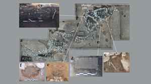
Figure 5. a) Overview of house F27, a type-D house from Xiangranggounan, with inset detail of: b) the eastern wall of F27-3; c) a burnt soil and ash pile in F27-2; d) six floor layers of F27-2; e) a hearth to the north of F27-4; f) the storage pit at the bottom of F27-9 (figure by authors).
Type D house F27 is notable for its sophisticated structure, consisting of nine rooms (F27-1 to F27-9) divided by stone walls (Figure 5a & b). Evidence of frequent reuse, refilling (Figures 5a, c, d, f & 6) and rearranging of internal space (e.g. F27-4 was partitioned as a cooking/storage room between two adjacent rooms, see Figure 5a & e) suggests a complex history of construction and inhabitation over several decades or even a century, as indicated by radiocarbon dating (Figure 2).

Figure 6. The western profile of trench IIT1: a) photograph; b) drawing (figure by authors).
The stratigraphic sequence in trench IIT1 on terrace II indicates a sequence of activity, from youngest to oldest: layer 1a → F10, F11 (type A) → layer 1b → F27 (type D) → layer 2 → F61 (type E) → layer 3 → layer 4 (Figure 6). Similar stratigraphic relationships were also observed in trench IT6, IIIT1 and IIIT2 on the other two excavated terraces. Based on these findings, we propose that settlements at Xiangranggounan underwent at least three developmental phases. Phase I was dominated by semi-subterranean, single-roomed houses with wooden posts. Phase II was characterised by semi-subterranean houses with multiple rooms separated by stone walls. Most type-B and type-C houses belong to phase I or II. In phase III, houses built on new surface-level bases and supported by stone walls became predominant. Although semi-subterranean houses persisted in this phase, their frequency of reuse and reconstruction is reduced compared with the earlier phases.
Discussion and conclusion
Xiangranggounan is substantially larger than other known Kayue cultural settlements, with an area nearly four times that of Mobula and more than 20 times that of Baoxiazang. Radiocarbon dating of the houses at Xiangranggounan indicates long-term occupation of the site, potentially for hundreds of years, with some complex houses (e.g. F27 & F33) being rebuilt and repaired multiple times. Preliminary archaeobotanical and zooarchaeological studies suggest an agropastoral economy at this settlement, including crop cultivation (barley, wheat and millet) and animal husbandry (caprine, cattle and horses), which resembles the economic practices of the modern villagers in this region. Based on current evidence, we suggest that Xiangranggounan represents a permanent settlement of the Kayue people and argue that a scenario in which settlements on the north-eastern Qinghai-Tibet Plateau became smaller and more ephemeral during the late Bronze Age (Shui Reference Shui and Shui2001: 308–11) does not apply to the Gonghe Basin.
Compared to Mobula (four type-E houses) and Baoxiazang (three type-A houses), Xiangranggounan yields a much larger number and greater variety of settlement structures.
So far, type-D houses have not been found anywhere else on the north-eastern Qinghai-Tibet Plateau. The type-B and type-C houses at Xiangranggounan are also the first examples to be found at a Kayue cultural site, although they are found at other Late Bronze Age culture sites in this region. The diachronic changes of house form at Xiangranggounan have not been observed in the Gonghe Basin and adjacent regions before. Given that the other two Kayue settlements exhibit only a single type of house each, and the exact chronological sequence between the two types of houses remains unclear, further fieldwork and research is required to determine whether the transition from semi-subterranean wooden-structured houses to surface-level stone-structured houses represents a regional pattern in the Gonghe Basin or a broader trend across Kayue communities on the north-eastern Qinghai-Tibet Plateau.
Funding statement
This work was funded by the National Social Science Fund of China (22CKG014) and the Major Special Project for Philosophy and Social Science Research, Ministry of Education of China (2022JZDZ024).


