Following decades of heated debate, the Classic Maya are now recognized as a fully urbanized society, having built a complex landscape of cities, towns, and villages embedded within an uneven mosaic of agrarian terraforming and land-use practices (e.g., Marken and Arnauld Reference Marken, Charlotte Arnauld, Marken and Charlotte Arnauld2023a). Combined with the recent proliferation of LiDAR surveys, this consensus has sparked a surge in studies of lowland Maya urbanism (e.g., Chase Reference Chase2016, Reference Chase2017, Reference Chase2021; Chase and Chase Reference Chase and Chase2016; Clancy Reference Clancy, Spencer and Werness-Rude2015; Houk Reference Houk2015; Hutson Reference Hutson2016; Isendahl Reference Isendahl2012; Landau Reference Landau2015; Marken Reference Marken, Marken and Fitzsimmons2015; Marken and Arnauld Reference Marken and Charlotte Arnauld2023b; Marken et al. Reference Marken, Ricker, Rivas and Maxson2019b; Rice and Pugh Reference Rice and Pugh2017; Smith et al. Reference Smith, Ortman, Lobo, Ebert, Thompson, Prufer, Stuardo and Rosenswig2021). Although ongoing, this research has highlighted that while Maya cities shared much in common in terms of architectural forms and components, each lowland city was unique in terms of its settlement ecology, occupational history, and overall socioeconomic composition. Recent comparative studies of Maya settlement clustering (Thompson et al. Reference Thompson, Walden, Chase, Hutson, Marken, Cap, Fries, Guzman Piedrasanta, Hare, Horn, Micheletti, Montgomery, Munson, Richards-Rissetto, Shaw-Müller, Ardren, Awe, Kathryn Brown, Callaghan, Ebert, Ford, Guerra, Hoggarth, Kovacevich, Morris, Moyes, Powis, Yaeger, Houk, Prufer, Chase and Chase2022), urban scaling (Smith et al. Reference Smith, Ortman, Lobo, Ebert, Thompson, Prufer, Stuardo and Rosenswig2021), and other lines of evidence, illustrate this variability in urban form and organization across the Lowlands.
Several recent studies indicate the importance of “place”—a physiographic set of circumstances upon which residents inscribe memory and meaning as they manipulate and cope with the inherited opportunities and challenges presented by that landscape—in developing the form and character of individual Maya cities (Marken and Arnauld Reference Marken and Charlotte Arnauld2023b; Marken and Murtha Reference Marken and Murtha2017; Webster and Murtha Reference Webster, Murtha, Lentz, Dunning and Scarborough2015). A second, although connected, concept vital to understanding the “character” (see, Jacobs Reference Jacobs1969) of a Maya city is that of the urban mosaic, the coupled ecological, social, economic, political, and religious webs that bound urban inhabitants and institutions into cohesive, negotiated civic units (Hutson Reference Hutson2016; Marken and Arnauld Reference Marken and Charlotte Arnauld2023b; see also Smith Reference Smith2019).
The papers in this Compact Special Section explore the variability in one facet of the Maya urban mosaic—residential differentiation and inequality by calculating Gini coefficients—across a range of lowland cities (Chase et al. Reference Chase, Thompson, Walden and Feinman2023). Originally developed to measure inequality based on household income in industrialized societies (see Smith et al. Reference Smith, Kohler, Feinman, Kohler and Smith2018), several classes of archaeological data have been used as wealth proxies to calculate Gini coefficients to measure inequality across a range of past neo-evolutionary sociopolitical types (e.g., Kohler and Smith Reference Kohler and Smith2018). Archaeological proxies of household wealth have included housing (household size and construction investment), burial goods, and domestic artifact inventories (see Smith et al. Reference Smith, Kohler, Feinman, Kohler and Smith2018: Figure 1.2 for examples). By analyzing the same two variables to generate Gini coefficients and Lorenz curves—residential size (m2) and construction volume (m3)—these articles enable a comparative assessment of Maya urban organizational variability beyond urban forms and histories (e.g., Marken and Arnauld Reference Marken and Charlotte Arnauld2023b; Marken and Fitzsimmons Reference Marken and Fitzsimmons2015; Martin Reference Martin2020), and provide an additional avenue to evaluate social variation both within and between Maya urban places (see Chase Reference Chase2017; Feinman et al. Reference Feinman, Faulseit, Nicholas, Kohler and Smith2018; Liendo Reference Liendo Stuardo2002; Smith et al. Reference Smith, Kohler, Feinman, Kohler and Smith2018; Thompson et al. Reference Thompson, Feinman and Prufer2021 for additional Gini analyses using settlement size and volume in Mesoamerica). While accepting that household size is a “form of embodied wealth” (Smith et al. Reference Smith, Kohler, Feinman, Kohler and Smith2018:23), household construction volume in Mesoamerica may also reflect generational episodes of rebuilding instead of simply wealth per se. This is relevant considering that “Gini coefficients are not inherently a measure of wealth inequality; they are actually a measure of unevenness in the distribution across a population of whatever observations the coefficients are based on” (Peterson and Drennan Reference Peterson, Drennan, Kohler and Smith2018:39). With these caveats in mind, Gini coefficients and Lorenz curves for settlement group size (m2) and volume (m3) for the Classic Maya city of El Perú-Waka' (hereafter, Waka') are reported here. The results reinforce the notion that many Classic Maya cities exhibited extreme regional inequality (Chase et al. Reference Chase, Thompson, Walden and Feinman2023), while highlighting that this trend is considerably muted when comparing inequality within urban zones.
The lowland Maya city of Waka', Peten, Guatemala
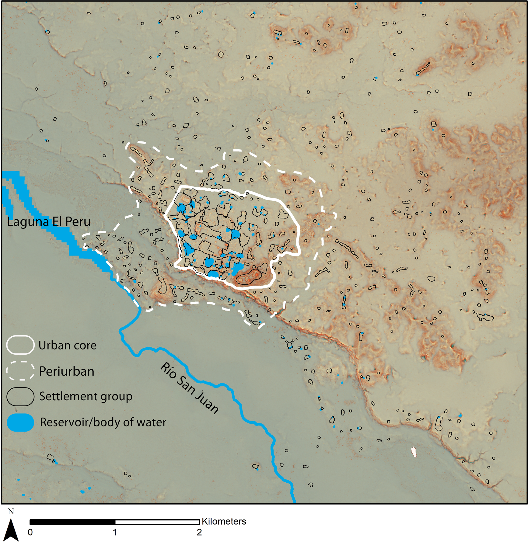
The ancient city of Waka' is located at the edge of the southwest corner of the Peten Karst Plateau in the Guatemala Lowlands, roughly equidistant from Tikal to the east and the Usumacinta River to the west. With its urban core, containing the monumental epicenter, at the edge of an escarpment plateau 80 m high, the periurban and hinterland settlement of Waka' stretches to the north and east across the plateau, as well as along lower-elevation upland areas to the south and west between the escarpment and the wetlands surrounding the Río San Juan (Figure 1). The urban core is characterized by one of the highest structure densities recorded in the Maya area, and demarcated on the south, west and southeast by the escarpment and on the north and northeast by an enigmatic boundary feature (Marken et al. Reference Marken, Pérez, Navarro-Farr, Eppich, Arroyo, Salinas and Álvarez2019a). The boundary separating the periurban near periphery from the hinterland far periphery is defined by the combination of topography and a structure density drop-off (see Marken Reference Marken2011, Reference Marken, Marken and Fitzsimmons2015 for detailed descriptions of these urban zones).

Figure 1. El Perú-Waka' urban zones and settlement groups used in Gini analysis.
Seen broadly, Waka' fits well with Fletcher's (Reference Fletcher2009, Reference Fletcher and Smith2012; see also Hawken and Fletcher Reference Hawken and Fletcher2021; Isendahl and Smith Reference Isendahl and Smith2013) model of low-density, agrarian urbanism (see Marken and Arnauld Reference Marken, Charlotte Arnauld, Marken and Charlotte Arnauld2023a). Eighteen years of pedestrian and LiDAR survey data describe a mid-sized monumental core embedded within a dense residential matrix, encompassed by a still rather dense, multipurpose, “periurban” ring, all surrounded by dispersed hinterland settlement dotted by village-sized settlement nodes exhibiting small-scale monumental architecture (Marken Reference Marken2011, Reference Marken, Marken and Fitzsimmons2015; Marken et al. Reference Marken, Ricker, Rivas and Maxson2019b). As stated, however, the most notable aspect of the Waka' regional settlement pattern is that the extreme aggregation of its residential surface remains within the urban core; very few Classic Maya cities exhibit such a high structure density (Marken Reference Marken, Marken and Fitzsimmons2015; see also Canuto et al. Reference Canuto, Estrada-Belli, Garrison, Houston, Acuña, Kováč, Marken, Nondédéo, Auld-Thomas, Castanet, Chatelain, Chiriboga, Drápela, Lieskovský, Tokovinine, Velasquez, Fernández Díaz and Shresta2018).
Defining settlement groups across the urban zones of Waka'
Archaeological surveys in the Maya area invariably rely upon the documentation of the remains of variably sized masonry platforms and structures, often referred to as “housemounds,” in describing and interpreting lowland residential settlement patterns (Ricketson and Ricketson Reference Ricketson and Ricketson1937). While the structure and form of lowland housemounds varies across the Yucatan Peninsula, in the region of Waka', like much of the Peten, these housemounds were typically constructed to create patios, a shared, leveled, outdoor living space. These patios, identical to the plazuelas of Belize, have been interpreted by archaeologists as individual household units based on the principle of abundance (Ashmore Reference Ashmore and Ashmore1981b) and confirmed by numerous intensive and extensive excavation programs across the Lowlands and Mesoamerica (e.g., Ashmore Reference Ashmore1981a; Robin Reference Robin2003; Wilk and Ashmore Reference Wilk and Ashmore1988; Willey Reference Willey1965). These single-unit patio groups, or households, are relatively easy to identify and define in spatial terms and are present in the periurban and hinterland zones of Waka'. It is when two or more such patio groups are located directly adjacent to each other, or when structures are associated with more than one patio space, that the one-to-one equivalency between patio group and household becomes more tenuous and subject to multiple possible interpretations, including lineages or “houses” (Gillespie Reference Gillespie2000; Vogt Reference Vogt1965; Watanabe Reference Watanabe2004; Wilk Reference Wilk1997). This is not the venue, however, to explore in detail the possibilities and implications of this aspect of variability in residential form for quantitative spatial analyses of Maya demography, aggregation, or, in this case, difference, using settlement data from the Lowlands.
With this in mind, the Gini coefficients presented here were calculated with data on Waka' settlement groups, which did not necessarily equate to individual households. Many almost certainly incorporated multiple households, although kinship ties likely connected settlement group residents. Spatial definition of individual household units at Waka' has proven difficult, particularly within the urban core, due to the high structure and patio density present, with numerous patio groups adjoined to one another. The settlement group boundaries within the sample analyzed here have thus been defined based on two, tiered factors: (1) topographic and/or architectural separation, even if rather minimal, and (2) an arbitrary distance of 30 m between architectural remains if present (e.g., Douglass Reference Douglass2002; Marken Reference Marken2011), based on ethnographic observations among contemporaneous rural Maya households (e.g., Boremanse Reference Boremanse1998; Vogt Reference Vogt1965). Examples of topographic and architectural separation include gullies, low-lying areas, or architectural terraces/platforms creating spatial distinction between settlement groups. These criteria result in many large settlement groups, again, particularly within the urban core, although some large periurban and hinterland groups—consisting of multiple adjacent patios—are represented as well. Within the Waka' sample area of 32.79 km2, 423 settlement groups, composed of one of more patio groups with less than 30 m spacing between them, have been defined using these criteria, three of which were excluded from the Gini calculations due to their clear monumental and non-residential nature.
Results: Gini coefficients for Waka' and each urban zone
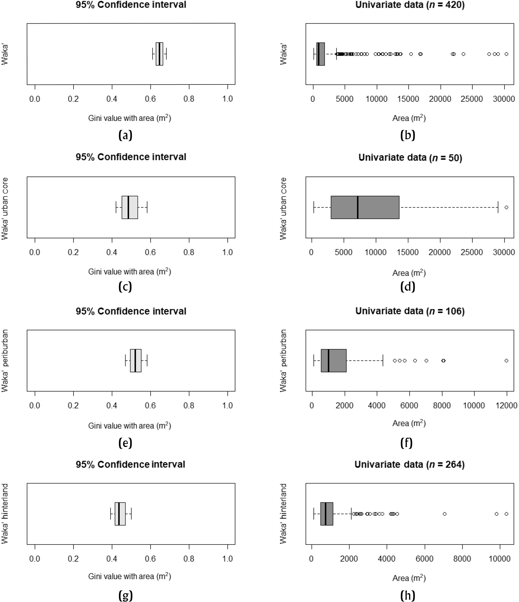
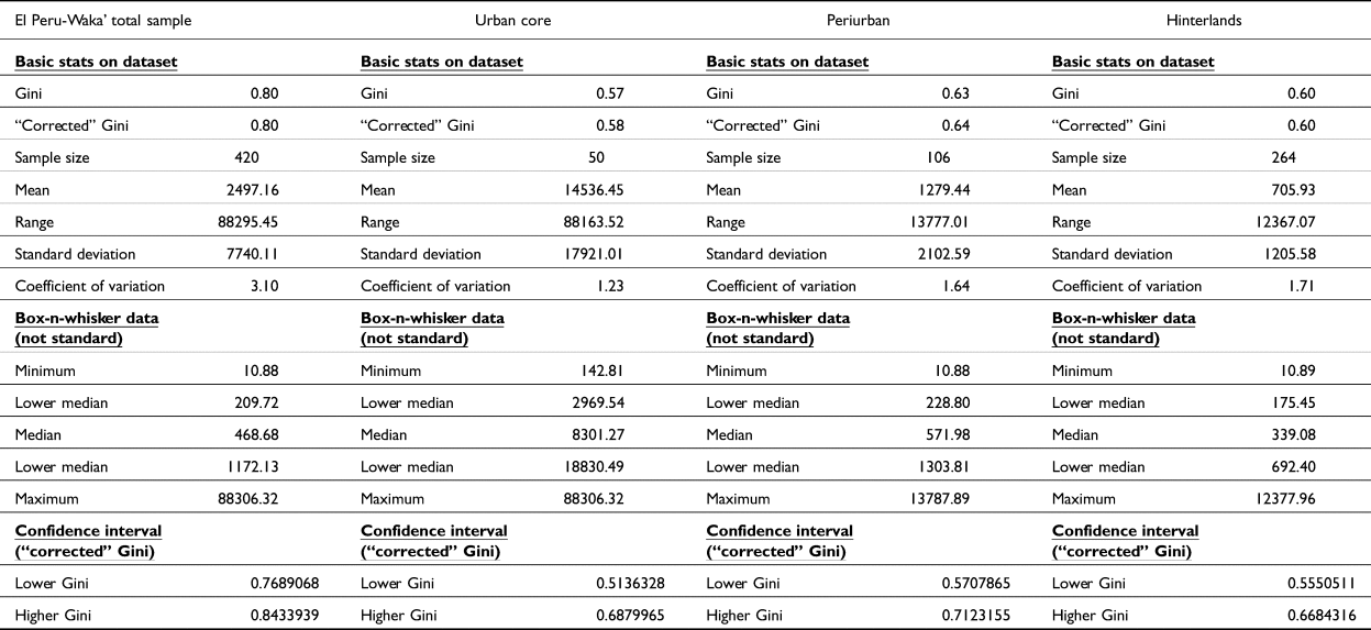
Gini coefficients and Lorenz curves were calculated following the methods described by Chase et al. (Reference Chase, Thompson, Walden and Feinman2023), using both settlement group area (Figures 2 and 3, Table 1) and construction volume (Figures 4 and 5, Table 2) metrics from 420 settlement groups at Waka'. As can be seen, Waka' settlement groups exhibit considerable differentiation, with a Gini coefficient of 0.64 when calculated using settlement group area (Figure 2a). This reflects the large areal size of many groups within the urban core; the 17 largest sample residential groups in terms of area are all located within the urban core (compare “Minimum,” “Median,” and “Maximum” values across Table 1). This high-level of differentiation between settlement groups within the Waka' sample is even more pronounced when using construction volume (Figure 4a). The Gini calculation with volume for the sample produces a coefficient of 0.80, indicating extreme differentiation, with the 19 highest settlement group volumes once again located within the Waka' urban core (compare “Minimum,” “Median,” and “Maximum” values across Table 2).

Figure 2. Gini coefficients for El Perú-Waka' settlement groups based on area (m2): (a) confidence interval (95%) for total sample; (b) univariate data for Total Sample; (c) confidence interval (95%) for Waka' urban core; (d) univariate data for urban core; (e) confidence interval (95%) for periurban; (f) univariate data for periurban; (g) confidence interval (95%) for hinterlands; (h) univariate data for hinterlands.

Figure 3. Lorenz curves for El Perú-Waka' settlement groups based on area (m2).
Table 1. El Perú-Waka' settlement group analysis statistics based on group area (m2).


Figure 4. Gini coefficients for El Perú-Waka' settlement groups based on volume (m3): (a) confidence interval (95%) for total sample; (b) univariate data for total sample; (c) confidence interval (95%) for Waka' urban core; (d) univariate data for urban core; (e) confidence interval (95%) for periurban; (f) univariate data for periurban; (g) confidence interval (95%) for hinterlands; (h) univariate data for hinterlands.

Figure 5. Lorenz curves for El Perú-Waka' settlement groups based on volume (m3).
Table 2. El Perú-Waka' settlement group analysis statistics based on group volume (m3).

Considering the general clustering of the largest settlement groups in terms of areal size and construction volume within the urban core, the Waka' settlement group sample was separated into the three, pre-defined urban zones described above—urban core, periurban, and hinterlands (Marken Reference Marken2011, Reference Marken, Marken and Fitzsimmons2015)—for further analysis. Gini coefficients and Lorenz curves were subsequently calculated for the settlement groups from each zone (Figures 2c–2h, 3, 4c–4h, 5) to determine whether the high degree of differentiation present across the total sample is also present for each urban zone (Tables 1 and 2). These calculations indicate that the high differentiation within the total sample is at least in part a result of its wide range of variation in both group area and volume, driven by the high number of large groups within the urban core compared to the other urban zones. For settlement group area, the calculated Gini coefficient for the urban core is considerably lower, 0.49, than for the total sample, while still indicating significant differentiation within the core residential settlement (Figures 2c and 2d). Analyzed independently, the Waka' periurban and hinterland samples similarly exhibit lower Gini coefficients of 0.52 and 0.44, respectively (Figures 2e–2h and 3, Table 1). Again, these urban zones still show considerable differentiation between settlement groups, but not to the extreme seen across the entire Waka' sample. In fact, the range of Gini coefficients for settlement group area between the three urban zones is small, 0.44–0.52, indicating similar degrees of differentiation between residents within zones, with the greatest differences occurring between inhabitants of different zones. The slightly elevated Gini values for periurban groups, compared to those of the urban core and hinterlands, is likely a result of the fact that most urban core groups are quite large, likely incorporating multiple related households, but of comparable size to each other, and most hinterland groups are relatively small in area, depressing differentiation within those samples. In contrast, most periurban groups are quite small, but with a few much larger in extent.
The lower Gini coefficients for each urban zone compared to the total sample calculation using settlement group area is mirrored when coefficients are calculated with settlement group construction volumes (Figures 4c–4h and 5, Table 2). In contrast to the area calculations, the urban core Gini coefficient of 0.57 is the lowest of the three urban zones when calculated with volume. As is the case with area, the periurban zone exhibits the highest Gini coefficient by volume, 0.63, and the hinterlands a coefficient of 0.60. The Gini coefficient for the urban core is depressed compared to the periurban and hinterland zones and represents less diversity in household construction investment. However, the urban core has many voluminous groups on average, ranging from approximately 143 m3 to 88,306 m3, effectively “canceling each other out,” while settlement groups in the periurban and hinterlands vary from 11 m3 to 13,788 m3 and 11 m3 and 12,378 m3, respectively. Despite this reduced overall range of variation, both the periurban and hinterland zones are dominated by groups of small housemounds, with a few clusters incorporating small-scale monumental/public architecture or vaulted, elite residential structures, considerably inflating their construction volumes, resulting in higher degrees of differentiation compared to the urban core (see Figures 4f and 4h). Despite this distinction, the range of Gini coefficients for settlement group volume is even more narrow than with area, while still indicating high degrees of differentiation between settlement groups within each urban zone. Once again, however, the degree of differentiation calculated using construction volumes within each zone is much lower than that calculated for the total sample.
Conclusions
Settlement group size and architectural investment centralization within the Waka' urban core reflect broader processes of settlement aggregation and ecology across the region. Similar to other Maya cities, and elsewhere, Waka' urban core aggregation attracted a range of civil and social services unavailable elsewhere in the region, including public politico-religious spectacles, community ritual events, and market opportunities (e.g., Eppich Reference Eppich, Masson, Freidel and Demarest2020; Freidel et al. Reference Freidel, Escobedo, Guenter, Sabloff and Fash2007), leading to the development of larger and longer-lived residential groups overall (e.g., Eppich et al. Reference Eppich, Marken, Menéndez, Marken and Charlotte Arnauld2023). The higher Gini coefficients exhibited by the periurban zone of Waka' with both metrics employed here demonstrates the variability of land-use and occupation of this zone; settlements with local community-scale monumental architecture are interspersed with quarries, agricultural zones, and small residential groups (Marken Reference Marken, Marken and Fitzsimmons2015). In contrast, the lower hinterland areal Gini coefficient expresses its greater relative homogeneity in terms of settlement size. In contrast, while hinterland settlements are typically small, there are a few larger nodes constructed with small-scale monumental or elite architecture to accommodate local communal interactions or events (see Walden et al. Reference Walden, Ebert, Hoggarth, Montgomery and Awe2019). Many hinterland settlements also tend to demonstrate less sustained occupation; occupants of the Waka' hinterlands were more likely to continue to rely upon settlement mobility as an adaptive strategy, frequently abandoning and resettling locations based on their evolving circumstances (Eppich et al. Reference Eppich, Marken, Menéndez, Marken and Charlotte Arnauld2023; see also Arnauld et al. Reference Arnauld, Lemonnier, Forné, Sion and Alvarado2017).
As is the case with most settlement data analyses, how units are defined, along with their relative scale, has a profound impact on results (e.g., Wong Reference Wong, Kitchin and Thrift2009). The enormity of several urban core settlement groups, as well as certain peripheral ones, was recognized following the first phase of topographic mapping of the city (Marken Reference Marken2011). While the high degree of overall differentiation between settlement group size and volume at Waka' might not be direct indicators of household inequality, per se, across its entire urban landscape, the above analysis nevertheless quantifies clear differences in settlement size and architectural investment both within and between urban zones at Waka' (see also Canuto et al. Reference Canuto, Auld-Thomas, Yagi and Barrientos Q.2023; Montgomery and Moyes Reference Montgomery and Moyes2023). More importantly, the present analyses enable earlier qualitative assessments of settlement group areal and volumetric difference to be compared effectively to other Maya cities and centers across the Lowlands, and advance the collective effort to better understand and conceptualize the nature of urbanization processes across the Maya Lowlands and the American tropics in general.
Acknowledgments
The author would like to thank Adrian Chase and Amy Thompson for organizing the original Society for American Archaeology session that led to this Compact Special Section, as well as for their comments and guidance in conducting the analyses presented here. Over the years, numerous scholars and students have contributed to research by the Proyecto Arqueológico Waka' (PAW); they all have my thanks and gratitude. Finally, I thank our local Maya workers, without whom none of our research would be possible.
Competing interests declaration
The author declares no competing interests.
Data availability statement
All relevant data are within the manuscript. Guatemala's Instituto Nacional de Antropología e Historia (IDEAH) requires that the exact location geographic coordinates of archaeological sites (such as geographic coordinates or point shapefiles of household groups used in the Gini analyses) cannot be disclosed to prevent looting. Field and lab research at El Perú-Waka' was conducted as part of PAW under IDEAH permit DAJ-285-2018 to Damien Marken and Juan Carlos Pérez.
Funding statement
Field research by PAW reported here was funded by grants from the GeoOntological Development Society and National Science Foundation (Dissertation Improvement Grant #0813733). LiDAR data were provided by the National Center for Arial Laser Mapping at the University of Houston as part of the PACUNAM LiDAR Initiative supported by PACUNAM. Digitization of the LiDAR data was supported by a Reassigned Time course release in fall 2021 from Bloomsburg University of Pennsylvania, now part of the Commonwealth University of Pennsylvania.


